Sunday, September 27, 2009

A wind we'll all remember

The final ascent

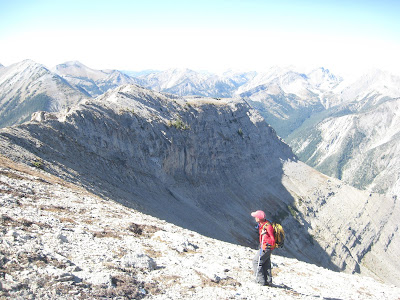
Mark Hertenstein walks the extraordinarily scenic ridge line 
The wind picked us up and slammed us down
Gale force winds Saturday added an element of challenge to a climb of Mount Richmond (elevation: 8,177 feet) in the Rocky Mountain Front/Bob Marshall Wilderness.
This was a Glacier Mountaineering Society hike I had organized. Eight of us began just west of Swift Reservoir on the North Fork of Birch Creek.
Richmond is a handsome limestone peak that towers above Swift Reservoir west of Dupuyer.
The plan was to pick up the first north ridge off the mountain we encountered and hook to the east and up to the top. I’ve done this before and it is an uncomplicated and straight-forward climb.
However my co-leader Mark Hertenstein thought we might make it more interesting by choosing another, more exposed ridge running off the north flank a couple of miles further up the trail.
The group agreed, and off we went making this an “exploratory” climb.
There are a number of ridges that run down to the North Fork from Mount Richmond, giving us a variety of choice.
Hertenstein thought the fourth one in the line of these ridges to the west might give us the best approach even though it meant hiking past the peak and backtracking to it.
We forded the North Fork and then bushwhacked through heavy forest and deadfall before coming into a lovely gully below a hanging valley at the base of the chosen ridge.
A number of climbers tried working their way up the ridge but couldn’t find a route and did some tedious and treacherous down-climbing.
Hertenstein then suggested side-hilling around the cliffs and climbing to the top on a ramp above the hanging valley. This turned out to be a wonderful suggestion and in short order we were walking on the summit ridge, with an easy ascent to the top.
The views on top were stupendous, enhanced by a bright, clear blue sky, although the predicted winds started to pick up. The Badger-Two Medicine area with Glacier Park peaks dominated the view to the north, the Great Bear and Bob Marshall Wilderness areas to the west, and the Rocky Mountain Front and its high Teton peaks to the south, the Great Plains flowed like an ocean of grass to the east punctuated by the Sweetgrass Hills. I particularly enjoyed the views in the Badger-Two, the peaks of sacred Blackfeet mythology --- Poia, Scarface and Morningstar.
I had expected more fall color than we saw, although the cottonwoods, and ground plants were a brilliant yellow.
At the top we considered the possibility of continuing the climb to the southwest by trying Mount Sentinel.
But, the kniferidge to its summit and increasing winds dissuaded us.
We considered the standard route down the east face, but instead opted for yet another of the ridges into the North Fork, off the smaller of the two Richmond peaks.
We worked our way down through several large cliff bands at the top, descending to broad ridgelines where the wind really began to howl.
At first we got quite a large laugh being blown about.
Then the winds became sustained and the laughing was over. I was thrown to the ground at one point and scratched my glasses and bruised my arms and knee on the sharp limestone rock. Jerry Moore was knocked down trying to help me up and then was knocked over and flat by the wind. He hit his head, but was not seriously hurt. The rest of us were thrown into rocks as we tried to move down the ridge. We could barely move at times and huddled together at points hoping the wind would die down. Paul Cogswell’s sunglasses flew off his face.
Finally, we had no choice but to move off the ridge to the east side that wasn’t getting as badly buffeted.
David Schuler, who retired from a career at sea with the Coast Guard and knows winds when he sees them, estimated the winds at “60 knots,” which he translated as 90 miles an hour.
I’ve been in high winds on the Front before, but I think these were the highest I had ever encountered.
The warm temperatures made them more bearable.
We finally got into the bottoms and enjoyed narrow, scenic small canyons dappled with fall colors before reaching the North Fork.
We all enjoyed the off-trail and unexpected nature of our exploratory, but it will be the wind that we’ll remember the most.

Wednesday, September 23, 2009

Mt. Frazier on a cloudless, hot fall day

Lots of hard work to get to this point 
Fabulous views on top

Running the scree down
Mount Frazier (elevation: 8,315 feet) is the big, handsome limestone mountain that comes into view at the end of the Blackleaf Canyon, west of Bynum, when you clear the high canyon walls.
The sky was cloudless, clear and deep blue Wednesday so I figured Frazier would be a good destination.
Jim Heckel and I chose the southwest ridge off the mountain attained at the big wash a couple of miles beyond the canyon just before the trail starts heading up to the pass behind Mount Werner.
We were surprised by an extremely hot day. We got on trail at 9:30 a.m., and it was already 71 degrees. By the time we got back to Great Falls at 5:45 p.m., it was 92 degrees.
Correspondingly, the conditions in the Blackleaf were more summer-like than fall-like despite this being the second day of autumn.
About the only thing in full color were the cottonwoods on the bottom and they were a lovely golden hue. The aspen were only spotting color and there was some color on the ground.
Last year at this time this area was ablaze in fall color.
We carried bear spray with us because were were aware that several grizzlies caught in snares in Dupuyer had been dumped in nearby Muddy Creek drainage. However, we saw no evidence of the bears where we were.
I enjoy the Class 3 climbing on the southwest ridge, but we varied from the usual route. We got into a gully below the ridge slightly to the north and climbed about 1,000 feet there until regaining the ridgeline to the top.
As promised, I hereby name that gully the Heckel Couloir in honor of Jim, although I’d rather call it Jim’s Hully Gully.
Although I’ve climbed this mountain a half-dozen times, I had forgotten how broken up the rock is. Toward the top the limestone rock is large and unstable and requires tedious concentration.
As is the case with most of the Front, the mountain offers exceptional views. Because it was so clear we could see the Sweetgrass Hills to the east, the Little and Big Belt mountains, the Front, the Bob Marshall, Great Bear, Scapegoat wilderness areas, and could pick out individual mountains in Glacier Park.
There was some evidence of a fire in the Bob to the south. It exploded into a mushroom cloud after we had descended and were driving home. We thought it could be the planned control burn in the Hoadley Creek area, although it seemed to far north.
Later this evening the fire colored the western horizon during the sunset and cast the Belt mountains in a purple haze.
It was very dry for this late in September.
I’d like to see some snow soon.

Sunday, September 13, 2009

Lockhart traverse in reverse

Walking the ridge line

What a fabulous place for lunch 
Jim Heckel negotiates the knife ridge
The Lockhart Traverse is one of my favorite hikes in the Front that covers a series of peaks including Teton (elevation: 8,416 feet) and Lockhart (elevation: 8,691 feet) on a thin wall that marks the boundary of the Bob Marshall Wilderness west of Choteau.
When I write that there are a series of peaks, I mean there are several peaks on this ridgeline that top 8,100 feet as well.
I generally count five peaks including Teton and Lockhart, while I think it would be fair to throw in two more. I’m not sure about the distance on the hike but would estimate it in the 12-13 mile range with over 4,300 feet of elevation gain.
What I love about this walk is its alpine nature and the fact that it affords tremendous views all the way across to Bob Marshall Wilderness in all directions. We could see the clouds of smoke from a Lincoln-area fire sweeping toward the Swan Range, another fire burning near Holter Lake outside the Bob, and could name the peaks in Glacier Park to the north.
We haven’t had as clear a day as Saturday in many years, in spite of the fires to the south.
I done this traverse about a half-dozen times, but what made this one special was that we reversed the traditional route that begins by climbing Lockhart from the North Fork of Waldron Creek drainage, adjacent to the Teton Pass Ski Area.
Instead, we started up the South Fork Teton drainage that has been a main trail for snowmobilers. It appears as though an ATV had been up the snowmobile trail recently, although it was well-signed as a prohibited use. Likewise, we found ATV tracks up the North Fork Teton as well. ATVs did serious damage to a sensitive wet-land spring area at the North Fork trailhead.
It appears as though fall color is coming late to this Front country this year. Perhaps it was the copious rain this summer that has kept the area green.
The climbing on this hike is pretty straightforward Class 2 and 3, although the knifey spine of Lockhart’s south ridge offers some exciting low Class 4. You don’t want to lose your footing here.
As we bushwhacked down and out the North Fork drainage we discovered some volcanic outcroppings, very unusual in this sedimentary mountain range of mudstones and limestone.
This was one of the best hikes of this summer season on one of the prettiest days.
Mark Hertenstein approaches Teton Peak

Monday, September 07, 2009

Wolf Butte summer finale

Jim Heckel and Pam Smith atop Wolf Butte

Peter Johnson assesses his next move through the rock 
Katie on her way down through the spires
Wolf Butte (elevation: 6,732 feet) is a seldom visited landmark in the Little Belt Mountains south of Geyser.
I usually climb it early each season.
This year I saved it for Labor Day weekend to share with a group of friends and my wife.
It is surrounded by private lands that can be skirted by carefully staying on state and Forest Service lands to a saddle between it and adjacent Granite Peak to the south.
The fun of this 1,500 feet climb is the boulder hopping.
Wolf Butte is a peak made up of granite boulders, some as large as a house that have been uplifted.
There is no trail from the saddle. You find your way around and across these boulders.
The view from the top are remarkable, revealing the buttes and island ranges of central Montana.
After climb the peak, we descended, got in the car and drove to Billings for the Big Sky Polka Festival.
What would you expect from a nice Polish boy?