|
| Alpine Forget-Me-Nots were in abundance atop Rogers Pass west of Great Falls on the Continental Divide Trail |
We weren't sure we were even going to get out last weekend with the intermittent rain.
But, we applied the Wayne Phillips rule: "don't make any decisions until you're at the trailhead," and had great hikes Friday, Saturday and Sunday.
The highlight of the weekend had to be the Montana Wilderness Association hike to the proposed Hall Creek oil and gas wellsite in the Badger-Two Medicine, just south of Glacier Park.
The hike was led by East Glacier Park physician Kendall Flint and the new Glacier Two Medicine Alliance staff member Leann Falcon, a Blackfeet tribe member.
I've included a recent newspaper article about the controversial proposal (bottom of this post), so I won't go into much here, other than to say that the Badger Two Medicine is a sacred spot to the Blackfeet and the site leased by Sidney Longwell of Louisiana is on a Blackfeet ceremonial spot, where there have been sweats and smudges.
There is no road to this area, and it is in dense timber in an unlikely ridgetop spot, so you need to guide to find it. Flint and Falcon were those guides, who guided the route and explained the issues involved along the way.
Longwell is fighting to drill, now most particularly for natural gas, and a long drawn-out administrative and court case has been fought, with no short-term end in sight.
 |
| The ceremonial fire pit |
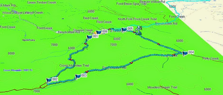
We started on private land, the Rising Sun Ranch, although this area can be accessed by the nearby Forest Service Trail 140. We hiked 6.7 miles, gaining and losing about 1,350 feet in elevation over moderate terrain. We were taken up a rough two track, supposedly no longer in use since the Forest Service ban on motorized vehicles there. There was evidence of fresh use, though.
There are a couple of Hall Creek stream crossings along the route, which climbs to a grassy ridgetop full of wildflowers (one of the best displays of Camas I had ever seen) that had only recently been dug up by bears. We saw obvious grizzly tracks and scat.
Below this ridge are several beaver ponds where you would expect to see a moose (there were signs).
To the north, this area's backdrop is Glacier Park and Calf Robe and Summit mountains and the Lubec area of the park.
 |
| Flint assessing fresh grizzly tracks |
There is no trail to the wellsite, but it can be identified by an opening in the dense tree cover.
Should a well be developed it would drastically alter the landscape because a road would be needed to haul in equipment, scarring the area.
What would happen to the abundant wildlife is not hard to guess. Flint said grizzly expert Mike Madel told a Badger Two Med Alliance gathering that bears congregate in this area to den for the winter and then disperse. There is a healthy elk population here, too.
This is lonely, windswept country that provides the solitude needed for the Blackfeet religious ceremonies. Industrialization would change that. (
See article at bottom of this post)
 |
| The Hall Creek well site hike route |
West Glacier hikes
We stopped at West
Glacier on the way into the park and took the Johns Lake/McDonald Creek trail
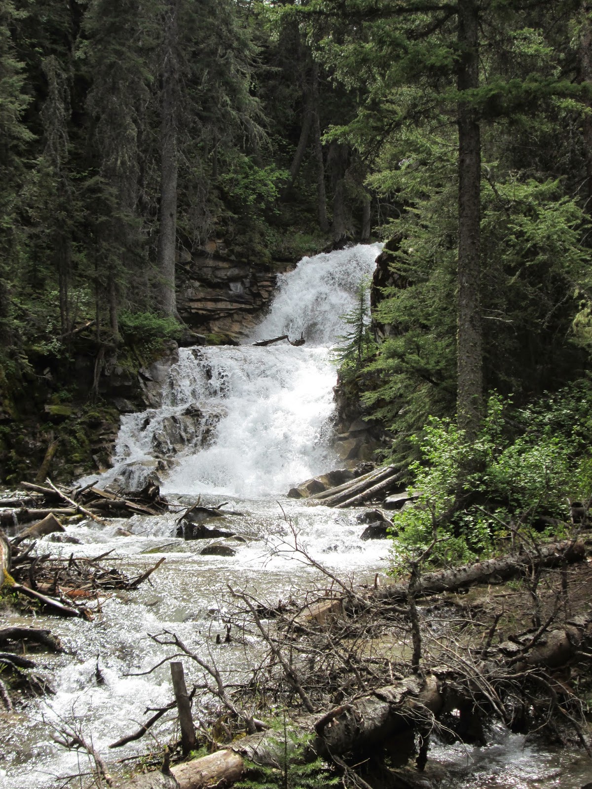
loop, and got exceptional views of a raging Sacred Dancing Waters stretch.
We searched for the
Harlequin ducks we had seen before in a backwater, but they were nowhere to be
seen.
It rained on us off
and on, but more sprinkles than outbursts, and we didn't get very wet.
This being early in
the season we didn't see many other folks willing to brave the wet and the
cold.
 |
| Sacred Dancing Waters of McDonald Creek beneath Mount Edwards |
We did not have the
spectacular alpine flower show that bedazzled us earlier in the day at Rogers
Pass, but enjoyed the tall hemlock, larch and cedar trees in this rain forest.
You walk in a forest canopy.
There is still a ton
of snow in the mountains and it is crashing into the creeks below.
On the way out of West
Glacier we stopped for supper at the Belton Chalet, where although the food is
steeply priced, it is well worth it.
 |
| Katie under the canopy of the west side forest of larch, hemlock and cedar |
Park Cafe demise/Many Glacier's Apikuni Falls
 |
| Katie at the foot of Apikuni Falls in Many Glacier |
We concluded our trip
on Sunday with a drive to Many Glacier via the Looking Glass Road from East
Glacier Park.We stopped in St. Mary's to check out what had happened to the
Park Cafe.To our dismay, there was little activity there --- just one diner ---
and an idle wait-staff that told us that there would only be one selection of
pie that day because the diner was out of flour! We were both amazed and
dumbstruck that his legendary eatery wouldn't have its assortment of pies.Yes,
it was the Park Cafe, but nothing like the Park Cafe we had come to know and
love over the years.Last fall, the long-time operators were forced out by the
lease-holder, a Blackfeet tribal member who decided to run the place.If Sunday
is any indication, this won't happen and I expect it to be out of business
quickly.It appears as though a park legend is going to die.This is a concern up
and down the east side of the park, where the Park Cafe is all the buzz.We took
a great, short --- 1.6 mile --- hike to the Apikuni Falls at Many Glacier.
Lots of snow at the top.While the lodge is open, Swiftcurrent Motor Inn
wasn't open yet and seemed busy training new staff under the leadership of
Xanterra, which has taken over from Glacier Park Inc., as the concessionaire.
 |
| The Hall Creek gas well is proposed for the heavily timbered hillside in an area above the opening where there is snow. It is also a sacred ceremonial spot for the Blackfeet |
The AP article: Hall Creek well, April 5, 2014
GREAT FALLS — John Murray, tribal historic preservation officer for the Blackfeet Tribe, opposes oil and gas exploration in Badger-Two Medicine in Lewis and Clark National Forest, a wild area of Montana that’s home to grizzly bears and a place of worship for Blackfeet.
Sidney Longwell, of Louisiana, has held a permit to drill for natural gas in the Badger-Two Medicine for 21 years, but his efforts have been blocked. He contends he’s being unfairly treated by the government in not being allowed to proceed after decades of delay.
The two men and others with a stake in what’s known as the Hall Creek oil and gas exploration lease met face-to-face Thursday in Great Falls at a meeting called to work out their differences.
The Great Falls Tribune reports that at the conclusion of the four-and-a-half-hour meeting, Longwell and Murray, the central figures, shook hands, but they could find little common ground, with Murray speaking of the ethereal qualities of the area, frustrating Longwell, who sought on-the-ground solutions to bridge the divide.
“What do you want to do?” Murray said at one point.
“I want to be able to go in and drill,” Longwell said.
“And that’s where we’re at an impasse,” Murray said.
Can exploration occur in a way that does not harm the spiritual and cultural practices of the Blackfeet Tribe?
Longwell thinks it can. Not Murray.
Natural gas development on federal lands and revenue it raises, how to protect an environmentally sensitive area, the government’s lengthy review procedures and the spiritual practices of the Blackfeet are part of the discussion in the energy-versus-environment debate.
Longwell’s fight isn’t directly with Murray, but rather the U.S. Forest Service, which called the meeting and manages the surface where the lease sits. Badger-Two Medicine is designated as a Traditional Cultural District, a designation requiring extra review when “undertakings” are proposed, in this case a natural gas exploration well.
The designation was given because of the spiritual and cultural significance of the area to the Blackfeet Tribe. As a result, the Forest Service is required by the National Historic Preservation Act to designate consulting parties to discuss limiting potential impacts of development before it makes a final decision on Longwell’s permit.
Key parties
And Murray, as the tribal historic preservation officer, is a key consulting party. Longwell, as the drilling permit holder, is too.
“We just can’t get off ground zero for either one of us,” Murray said at one point. “It’s not a very nice situation for myself. It’s not the way I like to be, but it’s the way it is.”
“It’s time to get something done,” Longwell said, noting several presidents had come and gone since the lease was issued in 1982 and the permit to drill in 1991.
Most of the consulting parties were at the table at the Lewis and Clark Interpretive Center on Thursday, trying to work something out.
“I would encourage us to at least try to talk to each other,” said Mark Bodily, forest archaeologist and Heritage Program Manager for the Helena and Lewis and Clark National Forest.
Murray says the Badger-Two Medicine is one of the Blackfeet’s last cultural and religious bastions, a place where Blackfeet people find spiritual enlightenment as well as food and medicine.
It is the tribe’s duty, he said, to ensure that the traditional cultural district continues for future generations. Building a well pad and a road into the area would disrupt the area and the “Blackfeet knowledge system,” he said, which he said was difficult to explain to those unfamiliar with the tribe’s ways.
“We want to keep that alive,” he said.
Holding on
The Forest Service has placed a moratorium on new development on federal land along the Rocky Mountain Front, and the government has bought out existing lease holders, but Longwell has held on to his.
On Thursday, he pointed out that the cultural district designation does not prohibit development.
“Let’s please get to mitigation,” said Longwell, noting he traveled 2,100 miles from Louisiana to attend the meeting.
The cultural district first was created in 2002. At the time, it was about 89,000 acres. It was expanded in 2013 to 165,000 acres. The proposed well is located within the expanded district, another point of frustration for Solenex officials. Solonex is the company that would do the drilling.
The well is located between Hall and Box creeks and about a mile-and-a-half from the border from Glacier National Park. Longwell said it could end up being one of the best producing natural gas wells in the Lower 48. A portion of the revenue from the project, he noted, will benefit the federal treasury.
His proposal, he said, involves 20 acres out of 165,000.
“Let the tribe give permission to go ahead,” Longwell said. “We’re ready to honor their religious beliefs. That’s not a problem.”
“But I’d like for them to at least give us some consideration, too,” Longwell said.
“Thirty years is a drop in the bucket on how long we’ve been interconnected with that land,” Murray countered.
Murray said he was not willing to budge on his position that no drilling be allowed in the district, but he said the tribe would support an effort to pay Solenex for its lease, maybe through tax credits, or a trade allowing it to drill someplace outside of the district.
Directional drilling was raised as a possible way to lighten the impact, in which the well pad would be moved out of the cultural district.
Longwell’s attorney, Steve Lechner, raised concerns about further delays if that were to occur, and asked what that would do to the project’s timeline.
Forest Supervisor Bill Avey said he couldn’t give a timeline because litigation or other issues could come up.
Consulting parties left the meeting with the goal of coming up a list of potential adverse impacts that might harm the integrity of the cultural district. Murray was reluctant to share the nature of the tribe’s spiritual practices, but said he would speak with tribal elders.
Lechner said the company can’t come up with ways to mitigate the impacts on the characteristics of the district if they don’t know what those impacts are.
There’s no deadline to resolve the issue at this point, Bodily said.
Ultimately, it will be up to the consulting parties to decide whether they want to continue talking. And it will be up to the forest chief to make a decision on the permit. At some point, The Advisory Council on Historic Preservation may be asked to assist in the process.