Monday, February 27, 2017

Sunset Mountain off Rogers Pass

Approaching the Sunset Mountain summit, which has three telecommunications towers 
Tele turns in the clearcut beneath the summit


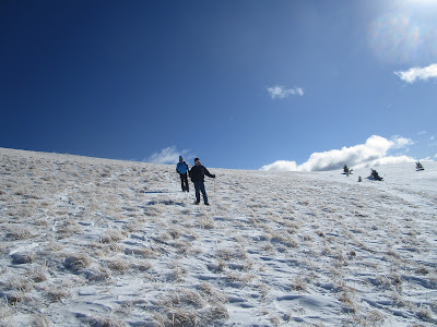
A sampling of the terrain along Little Wolf Creek Road

What was shaping up to be a wasted backcountry trip Sunday turned out to be the best trip of the season, although it was a short one.
We did a 6-mile up-and back, 1,100 feet elevation gain backcountry ski trip that started at Rogers Pass and ended at Sunset Mountain (elevation: 6,539 feet).  It followed the Little Wolf Creek Road to the top where there are communications towers.  There is no snowmobile traffic on this road.
This is generally a windswept area, so care needs to be taken to time the ski with a fresh powder dump.
The views in this area are exceptional as this road is located just to the east of the Continental Divide Trail.
There are numerous telemark opportunities from the top in the clearcuts to the south on BLM land.
We started hoping to do a Sun Canyon trip up one of the many gulches there, but when we got there we found no snow.
The route in blue from Rogers Pass
In a quick re-direct, we returned to Augusta and took U.S. 287 back to Montana 200 and Rogers Pass with hopes of finding something better.
We had long looked at that Sunset Mountain area up the Little Wolf Creek Road, but had always opted for the adjacent Continental Divide Trail on the west side instead.
The snow was coming down in buckets and we decided to give it a try.
The skiing was perfect ---- about a foot on top of a solid base, and the road rises steadily but gently.
We were quickly out of earshot from the Rogers Pass traffic.

Click here for a map and more details of trip: http://adventures.garmin.com/en-US/by/montana-tom/2017-2-26-cdt-sunset-mtn-near-rogers-pass/#.WLRbvd9tnZg

A road with a view

One of several outcrops

Sunday, February 26, 2017

Lots of odd snow for Nugget Creek run

The Nugget Creek route in Little Belts
So, here's the report on northcentral Montana's backcountry snow:  lots of new powder on top a crust that encases at least a foot of sugar snow that never set up.
As we skied Nugget Creek in the Little Belts Wednesday we could punch our poles through the various layers to the ground.
The snow on the bottom, deposited in December, just never set up because of the bitter-cold weather.
That was followed by more snow that was encased in the ice from a hard Chinook melt and some rain.  Then this week's powder ---- more than a foot over three days ---- Sunday to Wednesday and more coming.
This is the oddest ski season I've encountered.
On Mizpah Ridge below Mizpah Peak (Gordon Whirry photo)
When we could stay on the top of the crust it was great kick and glide skiing.  But, the crust would occasionally collapse and send us to the ground.  Yes, there was some "whoomphing" that cautioned us not to get on any steep slopes.  If we got going too fast telemarking a slope we'd often run into a wall of that collapsed snow that had the effect of running into large vat of mashed potatoes.
Nugget Creek is the Wayne Phillips' created alternative to the Porphyry/Ranch Creek run.  We call it simply "High Porphyry" or "Nugget Creek."
Once Ranch Creek headwall is reached, instead of dropping to the road, Nugget Creek ascends a 300 foot ridge and then drops south and east ultimately to Highway 89 at Mile Marker 123.
It covers 10.3 miles, rises 1,700 feet and drops nearly 2,900 feet.  It starts at Kings Hill Pass, goes up Showdown Ski area to the top of Porphyry Peak, across the ridge to Mizpah and then on to the Ranch Creek headwall.
Yes, we got some turns in and enjoyed a gorgeous, if cold and snowy winter day, but the snow was weird.

Tuesday, February 21, 2017

Snowshoeing Lazyman Roadless Area

At the beginning of our hike we ran out of snow and it was off and on with snowshoes

Pretty typical scenery along the trail

A view of Red Mountain through trees and blow down

The bright red line to left was our route
If nothing else, the Montana Wilderness Association has succeeded in introducing folks to otherwise obscure federal roadless lands in national forests that could be considered for wilderness with its Wilderness Walks and Snowshoe Hikes programs.
It's particularly important as the Helena-Lewis and Clark National Forest is preparing its forest-wide plan that could stand as a management document for decades.
Although I had lived in Helena for eight years in the 1970s I didn't do much hiking and skiing in the area between the old mining camp of Rimini and McDonald Pass.
Until Sunday I hadn't been in the Rimini Area for about 35 years.
An MWA Snowshoe Walk into the Lazyman Roadless Area east and south of Rimini introduced me to that area.
We took a trail that started at the old Moose Creek ranger station, now a forest cabin rental.  The trail leads to the top of Colorado Mountain (7,217 feet) and offers access to Black Mountain (7,149 feet) and a loop along the Lazyman Ridge.
Our group of a dozen snowshoers, led by Doug and Sonia Powell of Helena, only went up a couple of miles and 1,200 feet in questionable and crusty snow, but it gave us a fine overview of this 11,608 acres roadless area that's only a few miles from a densely populated Helena.  It is also in the shadow of the large Red Mountain near Rimini.  Doug pointed out various access points and trails into the area and the adjacent Jericho Roadless Area across the road near the Moose Creek Campground/Picnic Area.
The Jericho area, 8,440 acres climbs north to McDonald Pass.
Unfortunately, the Forest Service is not recommending either of these areas for wilderness.
The Lazyman area is densely covered by timber, much of which has been killed by bark beetle and blown down.
Aside from great views of the Black Mountain area, unless you get off trail and high, the views are of this timbered trail.
It looks as though it gets high snowshoe use.
If there were sufficient snowfall it would be very skiable, too.
The Helena Lewis and Clark National Forest is taking comment on its plan through March 31.


Wednesday, February 15, 2017

Valentine's Day in Glacier

The Front really showed off.  That's Headquarters Pass, Rocky Mountain Peak.

Katie at Lake McDonald in Glacier Park
Katie and I had a wonderful and sweet day visiting Glacier Park on Tuesday.
We caught the sunrise alpine glow on the Rocky Mountain Front on the way up, stopped in East Glacier Park to visit friends and hear stories about the 6 feet of snow that fell there last week, went to the head of Lake McDonald for a hike to the falls on McDonald Creek, and stopped for a Valentine Dinner at the Log Cabin restaurant in Choteau.
Mountain Pine Motel was buried

Main Street East Glacier at Sears Motel


Monday, February 13, 2017

Rodgers Peak in wind and wind crust

Being blown around on top of Rodgers Peak on CDT

Taking shelter 
Coming off the top


Near the trailhead
Montana is a land of such extremes.
First, too little snow.  Now too much in the Front and Glacier back country.
I've been out three times in the last week, twice up to Rodgers Peak on the Continental Trail above Rogers Pass outside Lincoln, and once up to the Mizpah area south of Showdown.
I've been bucking lots of snow after some parts of the Front got over 5 FEET in three days about a week ago.
The Rogers Pass area didn't get near that amount, but there is enough up there to make breaking trail difficult.
Last Wednesday I skied the the trail and found great snow in which I could telemark, making the trip particularly fun.
Then I went back again Saturday, this time with to lead a Montana Wilderness Assocation Winter Walk of 11 snowshoers.
Between Wednesday and Saturday we got a massive chinook that melted the snow in Great Falls and hardened the snow at Rogers Pass.
My ski tracks were still there, but they weren't much help on the heavy wind crust on the trail.  I'm afraid our showshoers sank a foot or more with each step much of the way.
When we got to the top it was windblown and the wind was howling at more than 50 miles an hour, enough to make the top a short, cold stop.
We got nice views along the CDT and an occasional view of Red Mountain and Caribou Peak and the Front.
The sun came out and once we got back in the trees our trip down was quite pleasant.
We'll need more snow if this trail is to be enjoyed on skis later in the season!
As a side note:  Skiing is one heck of a lot easier than snow shoeing.