 |
| A "selfie" at Dickey Lake in Great Bear Wilderness |
Although Great Falls is filled with smoke from the many fires, the area I chose was clear and less hot.
In the park I backpacked into Morningstar Lake in the Cut Bank Creek drainage and went for a look at Ole Lake via Firebrand Pass, and in the Great Bear traversed Grant Ridge and was challenged by brush on the hike into Dickey Lake.
The park was quite full of tourists and campers and I found myself irritated by the crowds in East Glacier Park, which has obviously been "discovered," transforming it into a busy hub rather than a sleepy byway.
I camped one night at the park's Two Medicine Campground, but opted for the less busy and quiet Red Eagle Campground near the Two Med damsite at the turnoff to the park. This Blackfeet run site is pretty disorganized and rustic, but the scenery (Scenic Point and Rising Wolf mountains) is stunning. I hope the Blackfeet are successful with this. This part of the park needs more campsites than the Two Med campground.
Finally, Morningstar Lake
 |
| Dawn breaks over Morningstar Lake in Glacier's Cut Bank Creek area |
 |
| One of the two moose I had in camp, just a few yards from my backpack tent |
I had been trying for a backcountry permit to backpack into Morningstar Lake for the past 10 years. I was lucky enough to score one on this trip and thoroughly enjoyed the trip.
It is roughly 7 miles into the lake via Cut Bank Creek, but I added another 3 miles after setting up camp and going on to Pitamakan Lake.
I had seen Pitamakan Lake from the high ridge above it many times on annual Dawson-Pitamakan hikes, but had never been to the lake. It was well worth the extra effort.
The camp at Morningstar Lake is very lovely, the lake more a beaver pond. I did see a beaver at work there as well as two young bullmooses who grazed within 100 feet of my camp.
The walk from the Triple Divide/Pitamakan trail junction is open and lovely, showing off spectacular waterfalls, and Bad Marriage, Eagle Plume, Medicine Grizzly and Red mountains.
It was a hot hike, but it cooled off at night with strong breezes blowing through camp.
I was joined by a couple from Minneapolis who were going into Medicine Grizzly Lake, a nostalgia trip for the husband who had been taken there as a child.
When they left me at the Pitamakan junction I was joined by a Michigan hiker on his way to Two Med.
Folks in camp were not friendly and I did not meet them.
In the morning I walked out, passing maybe four groups on their way to Triple Divide.
Grant Ridge traverse in the Bear
 |
| Great Northern Mountain, highest point in the Great Bear, dominated the western horizon |
 |
| The large glacier on the north face of Grant peak in the Bear |
 |
| Another selfie, this one at the Grant Ridge high point with southern Glacier Park peaks as backdrop |
Over the years I've been trying to hit the various U.S. 2 portals into the Great Bear Wilderness and Glacier Park.
Grant Ridge traverse was one of those portals.
It begins at the Stanton Lake trailhead/parking area and climbs the west side of the ridge, breaking through at the ridge top and then returns via a walk down the top of the ridge that descends to the east and a hidden trailhead just off Highway 2 about fourth-tenths of a mile from the Stanton trailhead.
It was a perfect hike for a blazing hot day. I was in the trees for most of the day, which opened in strategic parts revealing breathtaking views of Great Northern and Grant mountains, the two monarchs of the Great Bear. Ripe huckleberries helped, too. Where the trail to Stanton Lake splits, the Grant Ridge traverse is the left for and there is a wide stream crossing.
Once I hit the ridge line I got stunning views of Glacier Park's southern boundary including the St. Nicholas spire and two of the park's 10,000 foot monster mountains ---- Stimson and Jackson.
On the way up I could see milky green Stanton Lake recede as I climbed.
I did not see another person on this 11 mile roundtrip trail. I gained and lost 3,700 feet.
A look at Ole Lake
 |
| Eagle Ribs peak dominates northwest skyline as seen from Ole Creek trail |
 |
| Summit and Little Dog mountains above placid Ole Lake |
Over the years I've returned time and again to Ole Creek, mostly hitting it from the U.S. 2 Izaak Walton Ranger Station. Other times from the Fielding portal, which requires crossing the railroad tracks near the Snow Slip Inn.
I've been to the Ole Creek campground, and used Ole Creek to reach Scalplock Mountain and the boundary trail.
But until this trip, I had never been to Ole Lake at its head.
I had seen Ole Lake from the top of Summit Mountain.
I decided a long hike via Firebrand Pass would be my route to this remote backcountry lake and campground.
It meant starting at the Lubec trailhead, which required railroad track crossing.
I love the hike to Firebrand, some 5 miles and a gain of 2,000 feet, but I had never been down the other side of the pass, and it was just too inviting not to go.
It was a hot and clear day, but for the first time in many years there was no hard west wind blasting me at the pass.
The surprise was how steep the pass is going down into Ole Creek.
Another surprise are the animal trails that criss cross the mountainsides. It gave me some pause to decide which of the trails was the Park Service's Ole Creek trail.
It was another 3 miles down to the lake, the first 2 miles out in the open with terrific views of the back sides (north) sides of Summit and Little Dog mountains, so prominent from Marias Pass, and hidden and striking peaks like Eagle Ribs, Despair, Barrier Buttes, Soldier, Battlement and Skeleton.
I passed loudly through dense (grizzly) forest for another mile before reaching Ole Lake, a beautiful dark green lake in the shadow of Skeleton, Summit and Little Dog peaks.
I stayed awhile to drink in the remote beauty of this area before turning around the climbing back out to Firebrand and then Lubec.
To my great surprise I had seen no one all day long on this high summer day over 16.4 miles.
I had gained and lost almost 3,800 feet on this trek.
Dickey Lake in Great Bear
 |
| This snowfield calved into Dickey Lake while I was there |
 |
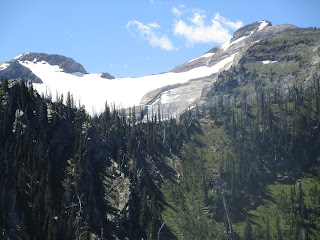
| My first view of the lake |
I had seen the Forest Service signs for Dickey Lake for the past 45 summers, and avoided it, thinking that a lake so close to a highway and Glacier would be overrun.
In fact, it was the last hike of my trip and I wanted something easy to do after my hike to Ole Lake the day before and saw that it is only 5.4 miles in length roundtrip.
Boy, did I get my signals mixed up!
It turns out that this is a very challenging hike despite its brevity.
This hike is located just one Forest Service Road west of Essex, and three miles up a logging road to a cramped parking area on the road itself. Forget parking at the trailhead, some 75 feet above the logging road.
There's a wade across Dickey Creek.
It didn't take long for this overgrown trail to close in on me and I found myself walking in thimbleberries, elderberries, cow parsnip, alders and stinging nettles above my head. I found the trail by feeling my way forward in a small rut. There was no way I could see a "trail" most of the way.
There were occasional glimpses of what was to come ---- a headwall with a big waterfall that I knew I would have to ascend to reach the lake.
At one point I lost the trail altogether in a large fern thicket that tossed me about.
This is where I think I lost my bear spray.
That gave me plenty to think about as I thrashed about in some of the most prime grizzly habitat I've ever seen.
At the headwall, the vegetation became less intense, and to my surprise there was a pretty good, but extremely steep climbers trail for the final two-tenths of a mile and 600 feet of vertical.
With several vegetable belays I reached the lake and felt that I had accomplished something and was richly rewarded with a great view. It had taken me 3.5 hours to cover the 2.6 miles to the lake! Because I knew the route on the way down, it took me 2 hours and 15 minutes. I had gained and lost just 1,400 feet.
Some easy hike!
At the south end of the lake are a couple of snow fields, one which calved into the aqua colored water with a crash while I was there.
High above there were waterfall rivulets coming off other snow fields.
I drank in the beauty of the area for more than an hour before my most tentative trip down the steep headwall.
I'm not sure I've ever seen such a crude Forest Service trail.
But what the heck, this is wilderness, man.
 |
| The waterfall at the Dickey Lake headwall |
 |
| This was my "trail." |


