Monday, July 22, 2019

Father Time takes his toll: Lockhart Traverse

On the Lockhart Traverse ridge line

Mark surveys what he plans to climb

On the way up

Mark opts against climbing Lockhart for a rest instead

It had been10 years since I last did the Lockhart Traverse ---- the knife-ridge walk between Lockhart and Teton peaks above the North and South Forks of Waldron Creek in the Rocky Mountain Front.
I can't say I did it Monday, but I did gitve it a try.
I'm finding the difference between being 61 and 71-years-old is pronounced on the aging downside.
We had a stunning summer day with light winds, temperatures in the 60s and a cloudless sky for this hike along an 8,000 feet ridge.
I just wasn't up to the task.
We thrashed our way up the North Fork of Waldron Creek to the bowl below the ridge.  This "trail" is nearly impossible to find and follow beyond a mile.  We had as much trouble locating it coming down as going up.  Nature has almost thoroughly reclaimed this area whose old growth timber was cleared away by a logging sale.  Massive trees and dense vegetation block the hiker and make path finding nearly impossible.  By the end of the day my sore knees had trouble clearing the enormous windfalls.
When it came time to summit Mount Lockhart I quite about 100 feet from the top, feeling that I had been there and done that, and not wanting to subject myself to the Class 4 scramble.
We spent plenty of time in that area, probably dooming any plan to walk the entire traverse to Teton Peak.
After doing the ridge line above the North Fork bowl, we decided to call it quits and bailed off one of the unnamed peaks.  Our bushwhack to the bottom was quite precariously steep, made possible by the trees we used to arrest hurtling to the bottom.
I'm pretty sure this was my last time to this spectacular ridge line.
The red is our route Monday; the fushia is the full traverse; the yellow is the high ridge line

Saturday, July 20, 2019

Mount Wright on a blustery July 19


Various views from the Mount Wright summit
We've had an exceptionally wet and cold summer so far.
I'll take that over heat and smoke from forest fires any day.
I'm late this year doing my annual Mount Wright (8,875 feet) climb.  It's one of the biggest mountains on the Front, but is easy to climb because of a great trail from the West Fork of the Teton.  It goes up a little more than 3,400 feet over 3.6 miles.
I've always said it has the best views in the Rocky Mountain Front --- across the Bob to the Swan Range, north to Glacier Park, south to the Scapegoat, and east across the high peaks of the Front and the Great Plains beyond, including Island Ranges like the Highwoods and Sweetgrass Hills.
I climb it annually to gauge what kind of shape I'm in.  I'm three weeks late this year because I was so sick and because the month of June was eaten up by our trip to Spain.  I had tried to climb it two weeks ago, but got distracted when a Glacier Mountaineering Society group showed up at the trailhead and persuaded me to accompany them on the Washboard Reef Traverse instead.
The wind was blowing pretty hard and it was cold.
When I reached the halfway point --- at a grassy saddle --- I started to assess ways to bail, thinking it might be dangerous on top.
Then, the sun cleared the shadows away and off I went.
I stayed as much below the ridgeline as I could when I hit the summit cap to avoid the wind gusts.
I had to put on two additional layers of clothes because of the cold.
Gosh, what a July!
I didn't stay long on top, but still got my breath-taking views I love so much.
There were still quite a few alpine Forget-Me-Not flowers on top, and one lonely Jones columbine.  Along the trail there was a great showing of various vetch, blanket flowers, and a single blooming hollyhock.
I was not surprised on my descent to see my old friend Bill Cunningham climbing up.  Bill was solo, a credit to his 75 years of age.
What a treat!

Thursday, July 18, 2019

A climb for the "Forgotten Five"

Me on top Forgotten Five Peak (Gordon Whirry photo) 
Gordon Whirry enjoys views from the saddle


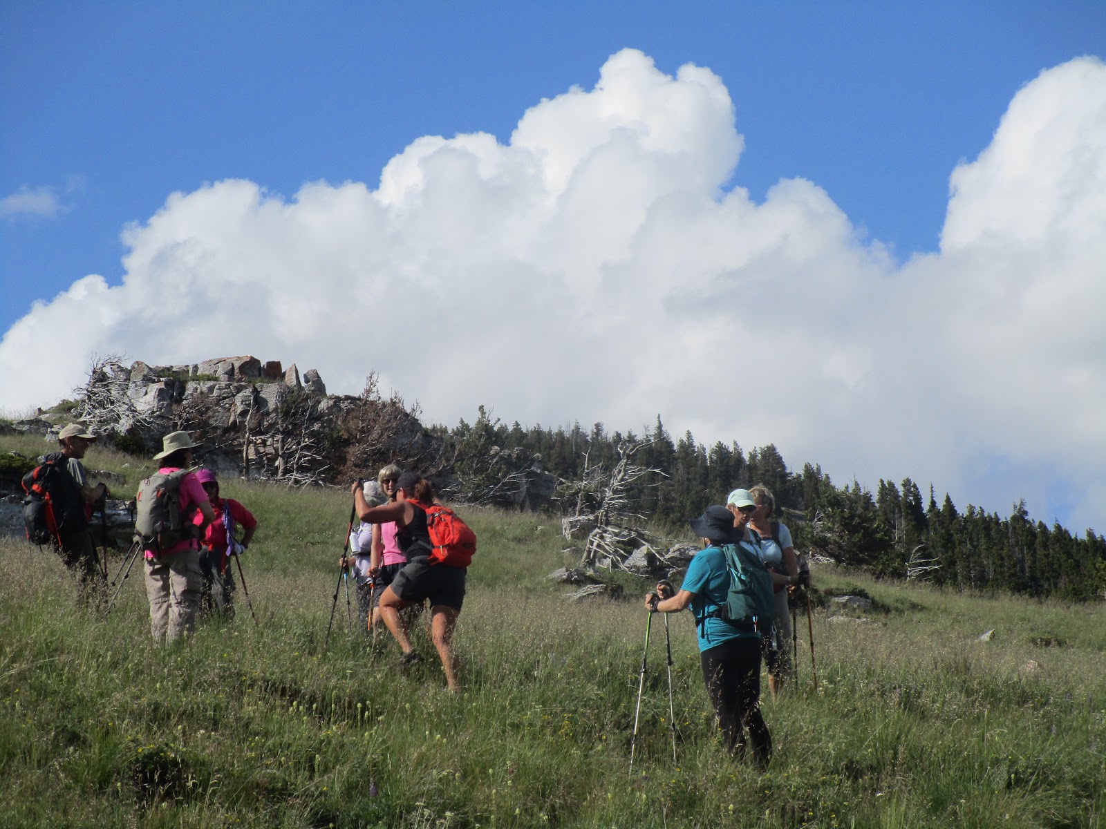
Walking the limestone knife-ridge 
Our descent above the 1931 Waldron burn


What we'd like to call "Forgotten Five Peak" in honor of the five firefighters killed in the 1931 fire


Our old guys hiking group, Wayne's Wild Wednesday Walks, has a decidedly Forest Service- firefighters bias with two of our members in that corps while in college.

We've been to Mann Gulch in the Gates of the Mountains country several times with Norman Maclean's "Young Men and Fire" in hand trying to figure out how several of the ill-fated smokejumpers in that Aug. 5, 1949 fire escaped death by running up hill through a break in the ridge to the other side. Thirteen died in that fire.

On Wednesday, with Charles Palmer's "Montana's Waldron Creek Fire," in our pack we explored the South Fork Waldron country near the Teton Pass Ski Area to understand how five firefighters died there Aug. 25, 1931.

While the Mann Gulch Fire is famous, the Waldron Creek fire is virtually forgotten.

Palmer has tried to put that right with his 2015 book that humanizes the tragedy and reveals the Forest Service liability for the deaths of these men who were blamed for their own deaths.

Palmer has seen to it that three of the men have new grave markers, found a fourth grave marker and has ascertained a fifth member is buried in an unmarked pauper's grave in the Chicago area.

Essentially, while the fire boss was attending to some other task, five firefighters broke off and ran downhill from a group of 25 others to attempt to put out what they thought was another spot fire and got trapped as it blew up and consumed them in this remote Teton Peak valley.

The five who died were: Charles Allen of Pittsburgh, PA; Herbert Novotny, 20, of Great Falls, MT; Harry Gunnerson (or Gunderson), 34, of Great Falls, MT; Ted Bierchen, 43, of Great Falls, MT; Frank Williamson, 24, of Great Falls, MT.  We stopped at the Choteau Cemetery and found the Gunnerson and Allen grave markers  that Palmer had provided.
The Gunnerson and Allen grave markers in the Choteau Cemetery 


Williamson grave in Great Falls Highland Cemetery 
Novotny grave in Great Falls' Highland Cemetery

While the Mann Gulch Fire is memorialized with markers where the jumpers fell, there's nothing in this South Fork drainage to indicate the 1931 tragedy.

Palmer has put up a cairn, which we looked for and could not find in this vast watershed that was burned in 1917 and 1931 and then logged. There is plentiful evidence of all those things.

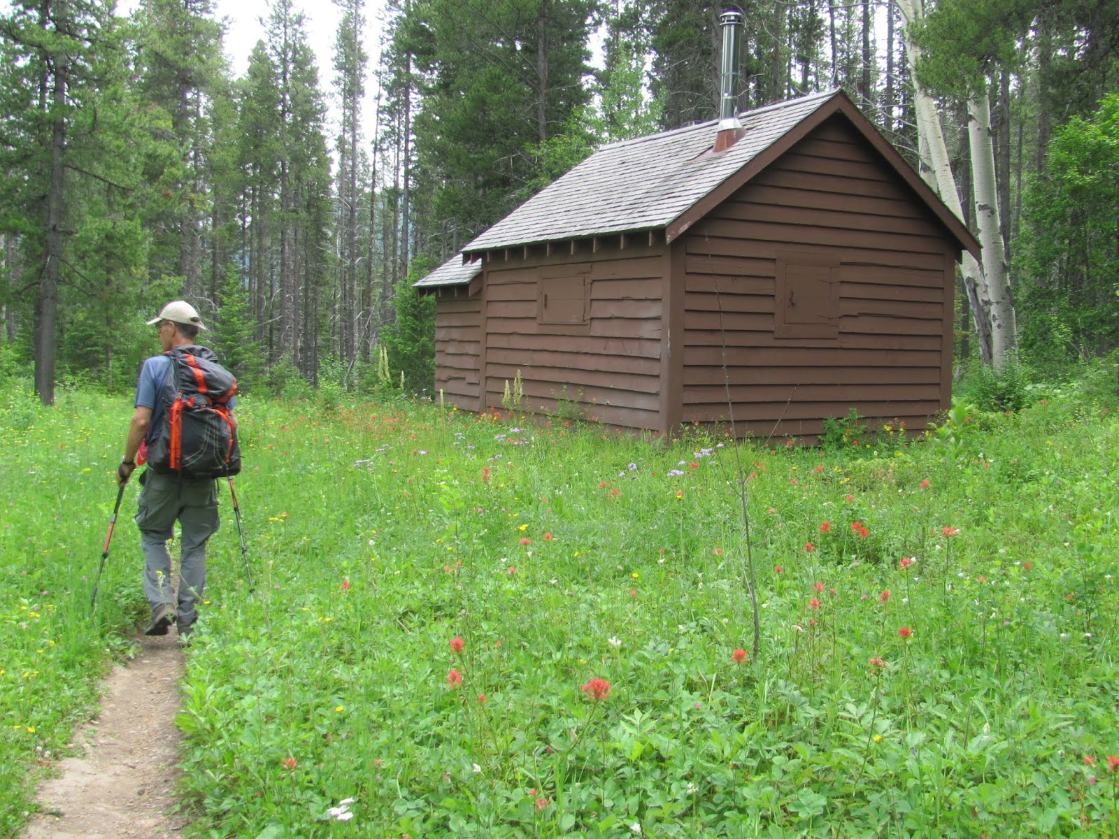
To find the area drive the Teton Canyon road that leads to the ski area and about a mile before you get there there's a marked Trail 193 that rises and falls in just a little over a three-quarters of a-mile to the South Fork where snowmobilers have constructed a make-shift bridge of lodgepoles over the creek. About 100 steps beyond the creek to the left there's evidence of small trail. It appears to be an old Forest Service or outfitters' trail marked by cut logs. We followed this up for about a half-mile and then cut over to the ridge line to the east and the ascended this ridge on a manageable angle. Then, it was a simple walk along the ridge to a saddle above the valley. We climbed the small peak to the east and larger peak, the high point, at 7,853 feet to the west.

We hiked 2.5 miles and gained about 2,200 feet to gain the peak. Along the way on the ridge we encountered sink holes that looked like they could be cave entry-points.

Along the ridgeline the views became more impressive the higher up we climbed. Here you are in the heart of the world class scenery of the Rocky Mountain Front with views of Mounts Wright, Lockhart and Choteau peaks dominant. It was breath-taking to attain the saddle as the Bob Marshall Wilderness high point, Rocky Mountain Peak, Old Baldy and Ear mountains became visible.

It was only 160 feet to the top from the saddle along a broken knife ridge of sharp limestone.

It appears as though others had been there before us as there was a rock pile on top. We added a cairn of five stones to commemorate the fallen fire fighters.

We all agreed that for the amount of effort, 5 miles round trip and 2,300 feet of elevation gain and loss, we had received a lot of bang for our effort.

In addition, we had spent the day contemplating the sacrifice of these men during the Great Depression.

Like Palmer, we had a hard time trying to figure out what really went on or where the men had fallen.

We agreed with him that they were truly forgotten and wondered if it might be appropriate to name this peak in their honor as something like, "Forgotten Five Peak," perhaps putting a plaque on top with their names and a description of the fire.

I think it would be appropriate.
Our route is in the red

Tuesday, July 16, 2019

A quick trip up Glacier's Elk Peak

I
An alpine floral show on the trail 
Gordon Whirry on top


Looking down Ole Creek drainage 
The Fielding Cabin

I'm still trying to recover my strength and am testing myself on familiar peaks.
I abandoned a planned backpack trip into the Scapegoat Wilderness Monday and substituted a quick climb up Elk Peak (elevation: 7,835 feet)  on Glacier Park's southern boundary.
While the climb isn't particularly long at 7.3 miles roundtrip, it is particularly steep, with most of the 3,300 feet gain done in 2.5 miles.
The trail never seems to let up and is stingy with switchbacks.
I love this area of Glacier, immediately west of Marias Pass and just off Highway 2 across the road from the Geifer Creek turnoff into the Great Bear Wilderness.  If you want to do this hike, look for the Fielding Ranger Station in the Park accessed from this site.  The parking is tight, only three spaces at an angle.
The first .82 miles is on what appears to be an old railroad section that had been hlogged or burned.  There's a crossing of railroad tracks and a short search for the trailhead.
In less than a half mile there's the Fielding work station.  Just beyond the trail forks, with the right fork going up the mountain and the left fork to Ole Creek.  This is where the trail shoots straight up.
There are terrific views of the the Great Bear peaks, with Grant and Great Northern peaks especially prominent to the south.  You're high above Ole Creek, flanked by Running Rabbit and Scalplock (lookout) peaks.  To the east, Little Dog (connected by a ridge) and Summit mountains dominate the scenery above Marias Pass.  There are spectacular views across the Great Bear and Bob Marshall wilderness areas to the south.  The Two Med country with Rising Wolf and Flinsch peaks rise to the north.
On top there's debris from the former lookout cabin that has been torn down.
We were treated by a great floral display:  from the daisies near the trailhead to alpine lupine, miner's candle, buckwheat and silky Phacelia.
It is an easy climb, very accessible to those of us in Great Falls, where the climber gets a lot for the energy spent and free of the crowds in the developed Glacier portals.

Sunday, July 14, 2019

Annual trip to Patrol Mountain

The Loomis couple on their way up to Patrol Mountain

There's still a spot of snow or two on the ridge

Samsara and Mark Chapman at the Patrol lookout cabin
There are several trips I try to take every year and Patrol Mountain, with its high perched fire patrol cabin is one of them.
Not only do I like to use it to check my conditioning, but I like to visit the lookout ranger there, Samsara Chapman Duffey, who is becoming a legend with her 23rd summer there.  I have had nice visits with her father and sister who have manned the Prairie Reef Lookout in the Bob Marshall Wilderness over the years as well.
Some years I miss here when she's taking a day off or I've arrived too soon.
On Friday I hit it exactly and got to visit with her and her husband, Mark Duffey, who had just finished fire fighting stint in Alaska for the Forest Service.
This was the first time I didn't get to visit with Rye, her adorable herd dog and fire lookout companion, who died at advanced age last year.
Sam always has interesting information about this area where the Scapegoat and Bob Marshall wilderness areas meet.  She told about a young grizzly who had visited down trail from the cabin and she showed me photo of a wolverine she took last year. 
Usually I am one of the first, if not the first visitors of the season.  This year she had already been there for two weeks and I was down the list.
It was an exceptionally beautiful and slightly hot day and the visibility was pretty good.
This 11.3 miles hike that gains and loses about 3,000 feet requires a cross back and forth of ice-cold and sometimes high Straight Creek.
This year the water wasn't particularly high or ice-cold.
The only other folks I met on the trail were the nice owners, the Loomis', of 2Js Food Store.
This couple had failed at a previous attempt at getting to the top, stopping at Honeymoon Basin a couple of years ago, but this time they made it for a visit with Samsara.
I've been doing this climb annually since 1981, so I figure this must have been my 38th time to the top.
Hope I can continue to add to that number!

Wednesday, July 10, 2019

The highs and lows of Mount Brown in Sweet Grass Hills

Emerging from the opening in Devil's Chimney to the cave's large cavern

Readying to enter the cave

June Sprout at the base of the Mount Brown summit cap

West Butte in the distance

At the saddle between Mount Brown and Mount Royal

It seems as though the Sweet Grass Hills are becoming an annual habit.
We returned Tuesday to climb the high point in the East Butte sector of this isolated Island Mountain Range north of Chester along the Canadian border and explore the Devil's Chimney Cave along the way.
I had done it once before more than 10 years ago, but from a different aspect than we climbed Tuesday.
The really unusual thing was that I had been asked to lead a group of 17 women from Great Falls' (Girls in Glacier) and southern Alberta  (Women of Wonder) all-women's hiking groups on this off-trail route.
We got 15 of those women to the top, in addition to me and Gordon Whirry, who assisted.
We also encountered a very significant health issue with one of the two women who did not summit.
Almost right from the start of the hike this Alberta woman lagged and at the Devil's Chimney decided not to go to the top.
When we came down from the top 3 hours later she seemed ready to go and hiked for about a mile when she broke out in a sweat and could hardly proceed down the steeply pitched down-trail about another mile from the car.
It took us a couple of hours to get her to the car on that last mile.
We got a call the next day that she had had a heart attack in the car on the way back to Alberta and she is in the ICU in a Lethbridge hospital.
This woman was obviously not fit enough for this hike to begin with and showed up in inappropriate footwear ---- the flat, uncushioned running shoes with toe fittings ---- and we later found out she had had heart issues before and had taken a nitro pill and a muscle relaxant while we were climbing the mountain.
What a nightmare!
We were lucky to get her back to the car.  She was lucky to get to medical care in time.
This was an obvious case of someone who had not disclosed an important health issue to us, who had overestimated her conditioning, and hiked without the proper equipment.
She had put herself and the entire group in jeopardy.
Linda Evans raises the "Holy Grail" to celebrate the top of Mount Brown
But on the positive side, another of the Alberta women who has been suffering from advanced cancer, had Mount Brown on her "bucket list," and came ready and able to climb the mountain, covering the 9 miles and 3,100 feet of elevation gain and loss quite easily.  Last year I led the same groups up West Butte's high point so she could gain that peak, and my wife had assisted her in climbing Gold Butte, so she now has fulfilled her dream list of all three high-point summits.
Humorously, when we opened the summit register in an old ammo box, there was a silver chalice, which we are sure marks this high point as the "Holy Grail" of the Sweet Grass Hills.
All 19 of us successfully wiggled our way through the tight opening of Devil's Chimney to enter the large cavern for group photos.  Many had never been spelunking before and were thrilled.  The cavern is unusual because there are two openings at its top that allow daylight to stream into it.
We had a beautiful day with tall grasses, puffy clouds, and lots of wildflowers.
These lush hills shoot up from the dry plains on the Canadian border north of Shelby-Chester.
I had climbed Brown from a public access point at Whitlash previously, but we wanted to go into the interesting and large Devil's Chimney Cave, so we chose a route southeast of Mount Brown across private land on the Meissner Ranch, which graciously gave us permission.
The Mount Brown high point is in the trees without any views.  Four years ago we climbed Mount Royal, more prominent from Chester, using much the same route as Mount Brown.  The two mountains share a long, grassy saddle. Mount Royal is 40 feet lower than Brown, but offers better and open and sweeping views of the other Sweet Grass Hills and Great Plains.  Royal's disadvantage are the many electronic signal devices and a road.
Incidentally, above the grassy saddle on Mount Brown and on the ridgeline there is a rough and now unmaintained trace of a trail to the top.  You'll be stepping over and dodging many deadfalls, but it is a better route than trying to negotiate the unstable talus on either side of the ridge.

Monday, July 08, 2019

Going to Waterton to avoid the 4th

Enjoying the 4th of July Canadian-style in Waterton Lakes National Park

We had a wonderful supper at the Prince of Wales
Lupine and Sticky Geranium filled in the fields in front of Crandell Mountain
Waterton has a gadget at trailheads to scrape noxious weeds from your boots

Wild Day Lilies along the Wishbone Trail
It is becoming routine to get out of Great Falls for the 4th of July to avoid the firecrackers and cherry bombs that shake our neighborhood with noise.
It was especially sweet to get out of the country this year to avoid President Trump's military show in Washington, D.C.
We took off for Waterton National Park in the Canadian Rockies, Glacier's sister park, for the 4th and 5th, and had quiet evenings, relief from Trump and a wonderfully uncrowded world-class park to enjoy.
Waterton's visitation is obviously down because much of the park is off-limits since the 2017 Kenow Fire ravaged it, even destroying the visitor's center and making most trails too clogged with deadfall to hike comfortably.
We found lodging easily and good prices and near-empty restaurants and shops, although just several days earlier on Canada Days (July 1) we were told the town was hopping.
There's construction everywhere.
A new Kilmorey Lodge is being rebuilt on the site where it had been destroyed by fire. It will open next summer.
The new visitor's center is a couple of blocks north of the main street, an enormous facility that takes up several square blocks, and several old cabins have been knocked down along the lake, making way for new starter-mansions.  It is to open the summer of 2021.
The Bertha Lake and east shore trails are open, but the Cameron Lake and Red Rocks roads were closed while we were there.  You could walk them, though, and Red Rocks is supposed to be open to driving any day.
That's driving some Canadian traffic to Many Glacier in the U.S., and those trails are clogged and expected to be even more congested later in the summer.  At least the Park Service is putting up a sign near the Babb turnoff to let folks know if there are any parking spots in Many, so they don't make that long drive just to be caught in a traffic jam or turned around.
The Park Service is going to have to do something about the Many congestion soon.
We split our two nights between a bed and breakfast in Mountain View Alberta about 10 miles from Waterton the first night and then the Crandall Inn inside the park the second night.
There's a lot of country to explore in Waterton, even with the closed trails on the east side of the park.  We found the Wishbone Trail on the west side of Waterton Lake a very pleasant, if unchallenging, but scenic trail to hike.  It goes through a marsh and aspen groves and eventually hooks up to climbing routes of both Vimy and Sofa mountains.
We spent a morning reveling in the gorgeous wildflower blooms in the open grass country.  We were a little later than last year but enjoyed large patches of lupine.
While there are still boat rides on Waterton, they no longer let riders off at Goat Haunt because of last year's fire in the area.  But, you can arrange a boat trip to the exciting Crypt Lake trail.
And....there's always strolling along Waterton Lake in town or making a loop of it by taking in Crandall Falls.
Even without some of the legendary hikes off limits (Bear Hump, Akamina, Cameron Lake, Carthew-Alderson, Blakiston Peak, Lineham Ridge) you can choose to relax as we did this 4th.

Monday, July 01, 2019

High summer, high country; Fairview and Washboard Reef

Coming off Fairview Peak 
The final large Willow Creek falls


On top Fairview

Laurie Lintner on top our Washboard high point

It might be the end of June, but the snow cornices continued to hang in there on Washboard Reef
This past weekend was set aside to gauge where I am now that I've seemed to shake this flu.
I led a Montana Wilderness Association Hike on Fairview Mountain on Saturday near Augusta and did an unplanned 15 mile Washboard Reef traverse in the Teton Pass country with the Glacier Mountaineering Society.  Both have become annual treks.
We had a glorious, clear day for Fairview Mountain, a gain of about 3,000 feet over 8 miles via the Willow Creek Falls Trail on the Front.
We saw nearly every flower imaginable ---- from early season Shooting Stars and Glacier Lilies to fields of brilliant blue Forget Me Not flowers.
This is a very easy climb with views that are exceptional ---- across the southern end of the Bob Marshall and Scapegoat wilderness country.
The well-built Willow Creek Falls Trail travels high above a limestone gorge offering thrilling dropoffs.
Everything is so green right now.  It feels like we're in Ireland.
On Sunday I had planned to climb Mount Wright in the North Fork Teton country,  I hungered for the snow-tipped views across the Bob.
My wife, with her Girls in Glacier group were also going to be doing this climb, a 3,200 feet gainer over about 7 miles. They were at the trailhead when I got there with a group of another 10 hikers.  I've never seen this many folks amassed here.
To my surprise I was greeted by Del Meuchel and his wife Gail from Missoula and Laurie Lintner from East Glacier Park, who were with that pack of 10 hikers.
I had happened into a Glacier Mountaineering group who were planning to do the 15 mile Washboard Reef Travers a drainage or two away from Mount Wright.
It didn't take much persuading for me to give up Mount Wright and join this old group of friends.
Although I've maintained my membership in GMS I have been dormant, a bit put-off by a couple of bad climbs a few years ago.
This is a true Rocky Mountain Front/Bob Marshall Wilderness ridge walk that climbs several small mountains along the ridgeline.  Along the way we gained and lost nearly 4,100 feet of elevation.
We had a perfect day with clouds showing up at the right time to protect us from a penetrating sun.
The flowers were as glorious here as they were Saturday at Fairview.
I was very delighted to be hiking with my GMS friends again.