Monday, August 28, 2023

Ice Caves in Snowies via Niel Creek

Looking back toward Windy Point mountain

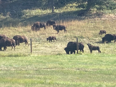
A buffalo herd on the Upper Niel Creek Road near the trailhead

This is how the ice caves get their name

The spectacular Volf Creek ranch as seen from the Snowies crest

 Although I've been to the ice caves in the Snowies a number of times I had only done it one time from the south, up Niel Creek outside the ghost town of Garneill.   That was seven years ago.

We retraced our steps to major cave and proceeded to the top of the Big Snowy Mountains ridge despite heat and haze.

The hike to the big cave is 3.8 miles from the trailhead, up some 2,300 feet.

We chose this hike because we knew that it would be in Ponderosa and Doug Fir shade most of the way.

Plus, it is a very quick way, another half mile to the Snowies crest where we walked another mile or so enjoying smoke-shrouded views to the north and south on this flat ridge.  We climbed to an 8,200 feet high point where we enjoyed a scenic break where we could make out the Little Belts, Castles, Big Belts and Crazies mountain ranges.  On a clear day it is possible to see to the Wyoming border and the Absaroka-Beartooth.  To the north, a piece of Crystal Lake, the Mocassins, and Judith mountain ranges.

What is especially pleasing about this hike is that it is a federal Wilderness Study Area.

For all but a few minutes we had this gem all to ourselves because the popular Crystal Lake access from the campground has been closed so it can be rebuilt.   No one else had chosen our Niel Creek route.

The quiet and peace was temporarily destroyed by three dirt bikes, in violation of the law that prohibits motorized vehicles in wilderness study areas, motored across.  I took photos of these guys, none of whom had license plates and turned them in to the district ranger. The most access is from Crystal Lake to the south. 

One of the miscreant dirt bikers in the Snowies WSA in violation of federal law


We figured that the dirt bikers had been emboldened because they figured no one would come into the WSA the way we did.

The Niel Creek route is the easiest way to the top of the ridge.  The Crystal Lake route and Grandview Traverse from that side is more scenic.

The Niel Creek trailhead is well off the beaten path, but has received better trail signs than it had when we did it seven years ago.  

The ice caves proved to be a great destination on a hot, hazy summer day.


Monday, August 14, 2023

Big trip of summer: Glacier, Waterton, Granite Park Chalet


The crowds in Waterton's Red Rocks Canyon

The alpine Swiftcurrent Trail beyond Devil's Elbow

If there was a symbol of the trip, it was Ted's selfie stick

Heaven's Peak was the main view to the west from Granite Park

The Swiftcurrent Mountain Lookout

You can see the chalet complex behind and below Katie on Swiftcurrent Peak

Katie and Joanna in front of the chalet

It was a tight fit for the four of us in our chalet room

At the beginning of our hike

On this wonderful trip we included Katie's brother, Ted and his wife, Joanna.

They added a lot of our enjoyment of a tour of both pieces of the Glacier-Waterton International Peace Park in Montana and Alberta.  I would crown them the champions of the "self stick" for all the photos they took of themselves with the Glacier-Waterton backdrops.  It was hilarious!

We had been to all the venues of this trip before, but that did not make it any less enjoyable.

We took our Napa Valley, CA guests on an exclusively east side of the park tour, starting with East Glacier Park and Two Medicine, up and over Looking Glass Pass and onto St. Mary and Going to the Sun Road with an overnight stay at the West Motel of St. Mary's Lodge.  At Goose Island we talked down to St. Mary Lake and Joanna submerged herself going after Ted's I-Phone he had dropped into the water.  We ferried a car to Many Glacier, where we planned to end our Swiftcurrent hike.  We saw two young grizzlies above the Sherburne Dam and two moose at Fishercap Lake before returning to St. Mary for the night.

The following day we set out from Logan Pass to Granite Park Chalet, an 8+miles hike on the thrilling Hi-Line Trail.

In the morning of the second day we parked our other car in the St. Mary Visitors' Center parking lot and took the first shuttle bus up to Logan Pass where we began our 8+ miles hike along the thrilling High Line Trail to chalet.  Our only wildlife were several bighorn sheet grazing below Haystack Butte.  The weather was somewhat smoky from the Canadian and Montana fires.  We were surprised by the number of runners on this crowded trail, many of whom carried no water or bear spray and were even shirtless.

On the third day we climbed to the lookout on top of Swiftcurrent Mountain after breakfast, arriving back at the chalet ahead of a drenching rain, and at 4:30 p.m., set out for the Grinnell Glacier Overlook, about a mile from the chalet.  We hurried because of the time and because a rain-threatening sky.  After a brief stop we headed down and Katie was waiting and warning me of a grizzly on the trail below us that had alarmed hikers near the chalet.

Our fourth day was consumed by the 8 mile hike out across Swiftcurrent Pass on a steep alpine trail that viewed the Swiftcurrent Glacier and numerous waterfalls spilling from it on a massive wall of rock.  When we got to Red Rocks Lake the rain started to pound us even as we hiked to the falls, and it continued to rain heavily for the next couple of hours.  We were simply aghast at the number of hikers who had brought no rain gear and were soaked and cold.  Our treat at the end of this wet trip was a warm shower in our rooms at the legendary Many Glacier Lodge, now crowded with wet folks all looking for a meal at the same time as us.

On day five it was off to Canada and Waterton Park via the Chief Mountain border crossing, open on the American side for the first time since COVID.  Before heading to Canada, Katie and I hiked to and around Josephine Lake beneath Mounts Gould and Allen while Ted and Joanna took the boat ridge, then a walk to Grinnell Lake and back to the Lodge. Then we immediately

 went for a drive along the Red Rocks parkway and a hike to Blakiston Falls, and then got Ted and Joanna checked into the magnificent Prince of Wales Hotel.  

Katie and I stayed with Laura and Barry Webster, cattle ranchers in Mountain View a dozen miles east of the park. 

On day six, exhaustion overwhelmed me from the non-stop travel and hiking and we did some shopping in downtown Waterton and a walk along Waterton Lake.  That was it.  I was so tired that it scared me.  I knew my trip was over.

On day seven, we drove the 225 miles home along the Rocky Mountain Front and were glad to be greeted by our cats.

Some quick takeaways from our trip:

  • Glacier Park was overbooked and a madhouse of people and cars
  • In contrast, Waterton had a calmer, less frenzied and more relaxing feel
  • The runners on trails in Glacier are an unpleasant distraction while hiking.  Many of them play loud music while running and don't carry bear spray or rain gear.  Their presence is a rudeness
  • Granite Park is a delightful experience and staying an extra day allowed us to do the Swiftcurrent Lookout and Grinnell Glacier Overlook day hikes leisurely.  I would have liked to have hiked to Ahern Pass as well
  • I had forgotten how steep and thrilling the descent from Devil's Elbow is on the Swiftcurrent Trail
  • There needs to be some numbers regulation on the High Line Trail.  It is overcrowded
  • There aren't enough private restaurants in the St. Mary and Many Glacier areas.  The food situation in both places is unpleasant
  • We were amazed at the number of license plates from southern U.S. states in Glacier.  They're streaming in from Florida, Texas, and Georgia in particular
  • Hikers in Glacier are simply unprepared with hiking gear for weather changes
  • I think the permit system needs to be re-thought.  Opening up the park after 3 p.m. is creating traffic jams of cars in anticipation of park entry
  • I'm convinced the best way to see Logan Pass and the hikes along the Going to the Sun Highway is to park, without a permit, at the Visitors' Center, and take the shuttle bus


Tuesday, August 01, 2023

A failure at Washboard a sign of decline?

Gordon Whirry with the smoke filled skies on the Rocky Mountain Front

This is where we turned back

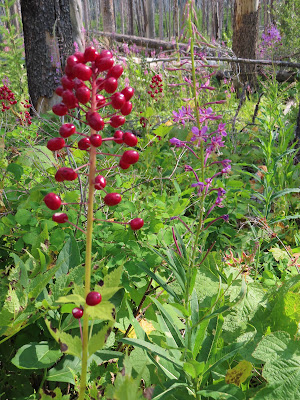
Baneberry and Fireweed lit up the ground

 I've done the 17-mile, 4,000+ feet Washboard Reef Traverse in the Bob Marshall about a half dozen times.

It has been one of my favorite hikes over the years, the last time having been 2019.

As I age into the "elderly" category at post-75 I'm trying to do some of the favorite hikes one last time.

Such was the case this week when I proposed the Washboard Traverse to hiking buddies Mark Hertenstein and Gordon Whirry, both of whom have done this hike with me before.

Well, it didn't work out as planned. 

We turned back around at a little more than a third of the hike worried that we'd lost daylight at the pace we were keeping.  Maybe I should say the pace I was keeping.  I've slowed down incredibly and my buddies kindly waited for me on many occasions. 

It could have been the heat.  It was in the mid-90s in Great Falls, and in the direct sunlight even a much lower temperature could have zapped us.

No, at least in my case I'm going to have to admit that I'm slowing down, perhaps precipitously, something that has been evident for some time but something I'll have to learn to accept.  I've been lagging behind in hikes for at least the past three years.  I can hardly keep up with my wife when we do our daily walks around the neighborhood.

Some of it may be this heavy leg syndrome that's been hanging around for the past three years.

Maybe it's the hammertoe on my left foot and bunions on both feet that make walking uncomfortable, painful at times.

Despite the aborted trip we managed to get in 3,200 feet of gain and covered 13.2 miles.

I particularly enjoyed the walk on the Continental Divide ridge starting at Teton Pass, with its amazing 360 degree views.

The Canadian fires smoke was somewhat heavy, obscuring and distorting spectacular mountain views.

I also enjoyed the bushwhack from the top of the ridge down a perpendicular ridge that plunged into thick forest, alders and all.  Mark led this part of the hike, something he's masterful at.

I don't think I'll be going back, though.


The arrows mark our route  

Headquarters Pass

The 7.5 miles, 2,000 feet elevation gain Headquarters Pass hike in the Bob Marshall is always a good hike.
Mike Dannells and I sent our wives off for their trip to Mount Assiniboine in the Canadian Rockies and agreed to spend some of our free time more productively this way.
Despite some haze and heat and 15 cars in the trailhead parking lot, we encountered only three groups and no horse trains packing into the Chinese Wall.
The always impressive major waterfall on the HQ Pass Trail

Mike Dannells at HQ Pass

The Rocky Mountain Peak ridge line is full of caves like these