Friday, June 28, 2024

A CDT section hike: Rogers to Flesher

Many dead trees litter this section of the CDT

A grizzly's calling card.  We saw seven piles along the way

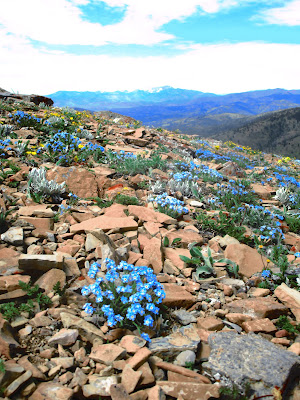
The late alpine flower bloom --- Forget-Me-Nots

We were blown away by a vast Forget-Me-Not bloom

The scenic marker of our CDT section

 Many of the section hikes along the Continental Divide Trail are worth repeating.

Such was the case Wednesday when we hiked from Flesher Pass to Rogers Pass, a jaunt of 13.5 miles with elevation gain in excess of 3,000 feet.

I've also skied this section twice.

It is a particularly nice hike in the late Spring and early Summer as the alpine flowers emerge.

I'm used to visiting the Rogers Pass area to see the flowers in late May and early June.  There they peak the first week of June.

So I was blown away by the display of blue Forget-Me-Nots and Jacob's Ladder blooms about half-way into our hike on a very steep hillside where there is a transition from forest to open slope.  This section is sort of scary as a misstep would send a hiker down precipitously.  I can't imagine how we did this on skis.

Tons of trees have died and collapsed on the trail between Flesher and this point.  We scrambled around a half-dozen in the trail.

While Forget-Me-Nots dominated this section, every quarter mile or so, a different alpine flower, like the Jacob's Ladder or Silky Phacelia would dominate.

Also in the trail at seven different points was sizeable grizzly scat.  There is a bear(s) frequenting this section of the CDT.  They had been digging for roots here, too.

We were disappointed that we didn't see any bitterroot, which we know is blooming now elsewhere, nor had the beargrass begun, although we saw some nubbins near the Rogers Pass trailhead.

To the west, Red Mountain, at 9,411 feet, the highest point in the Bob Marshall-Scapegoat wilderness complex provided a scenic backdrop.  I noted that most of the snow had already been stripped away, so it is climbable. 

I had expected to see other CDT hikers, but there were none.  We encountered a horseback party near Anaconda Hills from Wolf Creek's Blacktail Ranch of four who said they were doing a loop ride.

The skies were hazy and clouded up later in the day and the temperature heated up, but not as high as the 90 degrees in Great Falls.

We could see a small fire smoking near Lincoln to the south, but otherwise we were rewarded with great views of mountain ranges and buttes in all directions.


Monday, June 24, 2024

Annual Patrol Mountain climb

A glorious ridge walk to the top (Gordon Whirry photo)

Samsara Chapman at the lookout helm for the 27th year

We crossed a cold Straight Creek coming and going

The Patrol Mountain Lookout was framed in snow

Gordon Whirry in a field of buttercups in Honeymoon Basin

 Summer really begins after I've climbed Patrol Mountain in the Bob Marshall Wilderness and visited with ranger Samsara Chapman, now in her 27th year on fire duty.

I accomplished that Sunday on a blazing hot day in Great Falls with temperatures in the mid-70s at the lookout.

My goal is to climb the mountain through my 80th birthday, so I'll make four more annual trips on this 12+ miles, 3,600 feet gain and loss trek.

As usual, Samsara was a gracious hostess, and this year I really needed it because I neglected my electrolytes and crashed about midway up the mountain.  I've never considered the peak, which I've been climbing annually since 1982, particularly difficult, but this year I could barely make it up the final 1,000 feet to the top because of exhaustion.

After surveying me, Sam prescribed and fixed me a tall electrolyte drink which did a great job reviving me.  The trip down was a breeze, figuratively and literally.

Once my head cleared, Sam gave me and Gordon Whirry and tour of the blooming alpine flowers blooming around her wilderness perch.

She expects fire this summer as most snow is gone early.

The 360 views from the lookout are world class with the Scapegoat plateau and with the the high mountains of the Rocky Mountain Fron to the east and north and the Swan Range in the distance to the west.

The high pass just below the lookout is a multi-colored display case which reminds me of Neapolitan ice cream with its stripes and layers.

The only disappointment of the day was a less than stellar floral display.  The flowers du jour were globe flowers, columbine, buttercups, and sprinkles of lupine.

The day previous, Katie and I went to Paine Gulch in the Little Belts just outside Monarch and enjoyed a great bloom of Lady Slippers orchids.  On Saturday we did a leisurely  8.5 mile walk around Two Medicine Lake in Glacier Park.

Lady Slipper orchids in the Little Belts

My favorite late spring flower:  Camas in Badger Two Med

A couple of rascally hoary marmots in Glacier

One of the many moods of Glacier near Rising Wolf Mountain


Monday, June 17, 2024

All about flowers: Pioneer Ridge loop, Rogers Pass flowers, Mount Wright, Swan Lake, Kings Hill columbine and Highwoods Center Ridge


My daughter, Leila, on Center Ridge in Highwoods

A Calypso bouquet in the Little Belts

Camas in bloom at Rogers Pass

Jones Columbine on Kings Hill

Leila and Katie coming off CDT at Rogers Pass

Gordon Whirry atop Mount Wright with "Bob" behind him

Lots of late Spring activity to report.

Gordon Whirry and I did our annual Mount Wright climb.  In spite of downed trees I did the Pioneer Ridge loop in the Little Belts and returned to find Jones columbine on Kings Hill there.  Katie and I joined friends at the Laughing Horse Lodge at Swan Lake and did a hike to Holland Lake Falls.  And, there were several trips to Rogers Pass to view the alpine flowers and chocolate lilies. 

My daughter, Leila, joined us for Father's Day at Rogers, Kings Hill, and the Highwoods Center Ridge walk.

This is a magical time to hike in northcentral Montana's many mountainous areas.

We encountered enough snow on the Mount Wright trail that we had to skirt the trail and scramble to a ridge top to climb that peak.  The views from the top never disappoint, offering 360 views across the Bob Marshall and into Glacier Park and out on the Great Plains to the Sweetgrass Hills.

It's our great fortune to live so close to the Continental Divide Trail, and at Rogers Pass the alpine flowers emerged early this year.  We've enjoyed the progression of new, emerging alpine flowers on our repeated trips.  Beargrass is starting to emerge and should be in full display within a week or two.


Monday, June 03, 2024

Marking 20 years of "Out There With Tom": Mount Brown in Sweetgrass Hills


Mount Brown, tallest mountain in East Butte region of Sweetgrass Hills


Coming off Mount Brown was easier by taking the snow ridge down

At the Mount Brown summit with our Canadian hiking companions

In the Devil's Chimney cave

Me, coming out of the cave

This post marks 20 years of my "Out There With Tom," blog.

This blog has chronicled more than 1,000 hiking and climbing trips over those years.  I'm now 76 years old and not as energetic or steady on my feet as I was when I started writing this.

But the past 20 years have brought me endless joy and adventure in Montana's mountains that I've shared with my readers.

The first post was a Glacier Mountaineering Society climb of Singleshot Mountain in the St. Mary's Valley.

Today's post is Mount Brown in the East Butte section of the the Sweetgrass Hills.

I've done this mountain at least three times.  It includes a fun side trip along the route to the Devil's Chimney, a limestone cave that features a sunlight hole at its top, near a historic iron mine.

At 6,958 feet, it is the high point in East Butte, an area reached from Chester, the Liberty County seat.  It is about 35 feet lower than West Butte, at 6,983 feet, the highest point in this Island Mountain Range just south of the Alberta border.

Mount Brown's summit is unexceptional for its lack of views in a densely tree-covered top.

Most of the ridge line to the top from a saddle between it and the more scenic Mount Royal, was still snow-covered.  So most of our group dropped to an elk trail on the mountain's west face just below the ridge-line.

We came back to the saddle on top that snow.

The ridge is littered with blowdown trees that are easy to walk around.

Our hike began on the standard route through a gate and across private land (we got permission) to a faint trail on the east side of the mountains that had once been a jeep route to the iron mine.

We had wonderful views of nearby Mount Lebanon and Mount Royal through most of our trip.  From the saddle between Royal and Brown we could see the Rocky Mountain Front, Glacier Park, Waterton and the southern Canadian Rockies, Alberta's Milk River country, and the other Sweetgrass Hills, Gold and West Buttes.

There were elk signs everywhere, and the local ranchers warned us of bears.

There were wildflowers in abundance with bright, tall, deeply magenta-colored shooting stars most prominent.  We didn't see alpine flowers like forget me nots, Douglasia or Draba, though.

The Hills had been hard hit with drought the past seven years, the local ranchers told us, but they were smiling with considerable rain and snow this spring.  It was green everywhere.

The Hills are sacred to the Blackfeet Indians, and we saw evidence of that by the many prayer flags along the way.

Our route covered 11 miles with an elevation gain and loss of 3,200 feet.

The toughest part of the trip was trail finding.  There were portions where the trees had been damaged, many split in half, by recent snow and winds.  The most severe uphill was from the Devil's Chimney area to the Royal-Brown saddle.

Of the Sweetgrass Hills, this East Butte section is the most lush.