 |
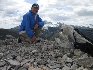
| Jasmine Krotkov took this photo of me on top Prospect Peak Wednesday |
 |
| Wayne Phillips crosses a snowmelt choked Shonkin Creek |
 |
| Up the ridge to Prospect Peak |
 |
| On one of the many volcanic dikes |
 |
| Flowers everywhere |
Prospect Peak in Highwoods
This 9.4 miles off-trail climb to the top of Prospect Peak (elevation: 6,621 feet) in the Highwood Mountains was conceived by H. Wayne Phillips.We started up Shonkin Creek, gained a high ridge line to the Peak, enjoying panoramic views of wildflower filled hillsides to the peak.
On the way down, it was on the ridge line all the way, a ridge that separated Shonkin and Kirby creeks.
While we were at the North end of this range, we had clear views of Highwood Baldy and Arrow peaks, as well as North, Middle and South peaks.
We ran into snow patches all along the hike, particularly at the top, which is really a large, narrow volcanic dike.
I climbed this peak years ago from North Highwood Creek, coming in from the west.
CLICK HERE FOR MAP AND MORE PHOTOS
Wind Peak in Rocky Mountain Front
 |
| Me on top with Ear Mountain in background |
 |
| Looking to the south from the top |
 |
| Wind Mountain |
This peak sits above the forks of the Teton River and its South Fork. To find where to start, go up the South Fork Teton Road and about a mile beyond the Forest Service boundary sign look up for the mountain and saddle immediately to the west.
Start up, aiming for this saddle. There are plenty of game trails to make the going easier. Once at the saddle, the best advice is stay left. There are several walls to be climbed and are most easily climbed on the ridge line to the left. Once just below the summit cap, follow it on a pretty good game trail to the RIGHT and at the end of the cap there's an easy spot to scramble up.
Coming down, retrace your way through limestone scree, the same way you went up, but as you approach the saddle, start angling down, looking for great ski skating for the final 1,000 feet.
This is a 1.6 miles, 1,550 feet climb.
The 360 views are incredible ---- Ear to the southeast, Rocky, Baldy to the west, to the north the Jones Creek peaks, particularly Choteau Mountain. To the east, the Great Plains; look closely for Sweetgrass Hills, Highwoods and Little Belts.
On Tuesday, the wildflowers were beginning to emerge and the high peaks of the Front had pretty good snow, while where I was at, around 7,000 feet was clear enough to climb easily. And....no wind!
CLICK HERE FOR MAP AND MORE PHOTOS
No comments:
Post a Comment