 |
| I picked the wrong route and we paid the price |
 |
| Reaching the summit cap |
 |
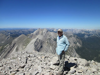
| On top, with mountains upon mountains in the Bob Marshall Wilderness as my backdrop |
 |
| Chip Myers below Rocky Mountain Peak, the Bob Marshall Wilderness high point |
But Sunday's climb on a clear, hot day proved somewhat challenging because I was insistent on choosing bad routes.
I've climbed this peak three different ways over the years. I think I've summited some 20 times over the past 30 years.
The most direct route is from the east, but involves a slog up scree. The most challenging route is from Headquarters Pass via the north ridge on a jagged ridge.
We went to the west saddle by way of HQ Pass, dropping 200 feet west from the pass and gaining the saddle, some 600 feet above us to the south.
In years past we've gotten into a large gully to the north of the saddle and scrambled up, using our hands at times.
I'm not sure why, but I decided to bypass the gully and went slight south and then up. We immediately got into Class 3 rock and gradually picked our way up about 900 feet, using our hands most of the way. About 150 feet from the top I could see the easy gully I had by-passed. Bad mistake!
On top it was about as calm and clear as I can ever remember. The 360 views were amazing! To the north we could see the high Glacier Park peaks ---- St. Nick, Stimson, Rising Wolf, Divide. Directly in front of us, strikingly handsome Old Baldy. To the west, Pentagon, Silver Tip, the North Wall, the Chinese Wall, The Sisters, Red Buttes, Prairie Reef. Further out, the Swans, Holland, Great Northern, Swan Peak. To the south, the Scapegoat Plateau as far out as Red Mountain, which we had climbed last week. To the east, the brilliant limestone peaks of the Rocky Mountain Front, and beyond them the butte laccoliths, the Island Ranges like the Sweetgrass Hills, the Highwoods, Big and Little Belt mountain ranges. And....the Great Plains!
We decided to descend the east ridge line and then from the saddle down the giant scree fields to the trail near the great spring.
Once again, a great error in judgment by me.
Once we hit a large break in the ridge line, instead of sticking with it, I followed my step-son down scree and talus through a series of cliffs, which, because of my caution, took us forever to get through.
Finally, we hit the scree and it was smooth sailing, on plan.
But, I was severely embarrassed.
 |
| The nanny became aggressive when we approached, so we made a high trail around her and her kid |
While I always expect to see goats at the pass or at the spring or at Our Lake trail over the next divide, I had never seen them so low on the trail, grazing right on the trail.
The best guess I could come up with is that they were seeking salt from horse urine as packers frequent this trail.
I suspect I'm going to need to go back later this summer and reclimb the peak just to refresh my memory and restore my route-finding confidence.
For a route map and more photos, CLICK HERE
 |
| HQ Pass trail far below us |
 |
| Finally through the ugly talus |
No comments:
Post a Comment