 |
| Katie with the eastern larch in full color at Upper Rowe Lake at Waterton Park |
 |
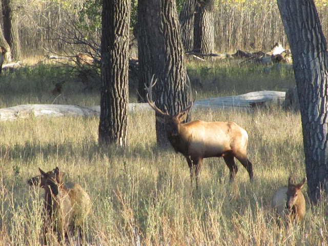
| This big bruiser stayed busy with his harem of 40 cows and fending off intruding young bulls at Slippery Ann in the Missouri River Breaks |
 |
| On top the Rierdon Gulch Ridge |
My, this has been a busy time.
In the past 10 days we've been to Salt Lake City for Katie's son's wedding, traveled to the Missouri Breaks near Winifred to view the annual elk rut at Slippery Ann, ascended the Rierdon Ridge, and done three days in the Waterton Lake National Park and nearby Castle Mountain Provincial Park.
 |
| The new Astro Turf football field at Winifred High School, compliments of $40 million school project donated by Winifred native Norman Asborjnson |
Slippery Ann-Winifred
The Slippery Ann trip has become an annual event. This time we brought along several friends to enjoy the elk mating ritual along the Breaks, and we weren't disappointed. The herds were large, close and very noisy bugling.
Instead of camping, we traveled to nearby Winifred (population 163), an extremely isolated ag trade center to stay at the International House, an upscale hotel in this outpost.
We discovered why there's such a ritzy place there when we had a chance meeting with its out of state owner, Norman Asborjnson, a Tulsa heating and cooling magnate who grew up in Winifred.
He's shared his $500 million fortune with his hometown by giving it $40 million to overhaul its school of 110 pupils.
The upgrade includes an Astroturf football field, an airplane hangar with three planes to teach flying, and the highest tech instructional equipment available.
Asborjnson has been funding full ride scholarships to Winifred High School graduates for the past four years.
This stop was even more impressive than the impressive elk show.
On the way home we reveled in our central Montana trip, stopping at the ghost town and boot hill cemetery of Kendall in the North Mocassin Mountains, driving the highway between Hilger and Fort Benton, and enjoying the golden cottonwoods in that river town.
 |
| Gordon Whirry atop the Rierdon Ridge in the Rocky Mountain Front. Ear Mountain in distance. |
Rierdon Gulch Ridge
We had set out to do an out and back to the saddle between Rierdon and Slim gulches where the Bob Marshall Wilderness began.
But, I got seduced by the Rierdon Ridge about three miles into the hike, and we bushwhacked up to a 8,177 feet unnamed peak, a climb of 1,600 over less than a mile.
The suffering was worth it, though, for the remarkable views along that ridge line.
To the west there were Rocky and Baldy peaks, two of the highest in the Bob. To the east, Ear Mountain; north, the sweep of mountains all the way to Glacier Park; to the south, the Scapegoat country.
It was relatively clear and sunny with no wind, so we bathed in the sunlight.
We walked for some distance down the ridgeline back north above our trail below. It became a bushwhack. It was very much unlike the ridge line to the south, which Gordon and I had done last year, an open, grassy walk. We had hoped to drop back to the trail at a low point marked by an outcropping we had spied while hiking below. Unfortunately, we missed that outcrop and started down prematurely and extremely steeply before reaching the trail as Rierdon Gulch began to run out of daylight.
We reached the trail by about 7 p.m., in time to watch the full, harvest moon rise.
As Mark would say, we left no daylight on the table.
 |
| Katie at Upper Rowe Lake in Waterton |
 |
| A beaver dam at Castle Mountain Provincial Park near Pincher Creek, Alberta |
Waterton and Castle Mountain Provincial Park
We had a pleasant visit with Laura and Barry Webster who ranch outside Mountain View, Alberta about 12 miles from Waterton Lakes National Park.
Laura is Katie's Canadian counterpart for a women's hiking group, and the two of them have coordinated hikes on both sides of the border.
This trip was for Laura to show us the Barnaby Lakes in the Castle Mountain Provincial Park, immediately north of Waterton in the Canadian Rockies. She also took us the the elk rutting grounds at Waterton near the Horse Stables on the Waterton flats where we saw the bulls with their harems in full rut.
Laura also suggested hiking to Upper Rowe Lake off the Cameron Lake Road in Waterton to view the east side (of the Continental Divide) larch. We did that hike of just under 10 miles and enjoyed a spectacular display of that tree in full color. It is a spindlier, smaller tree compared with the western larch on the west side of Glacier National Park, which we view annually in late October. However, it was quite a treat to see these trees in their golden splendor.
We were impressed with the the lake, that sits in an amphitheater of high rocks between Rowe and Lineham peaks. I had seen this lake from above when I did the Blakiston to Lineham ridge walk with Mark years ago.
The following day we started up the Barnaby ridge in Castle Mountain Park, a very steep climb, but had to turn back because of high winds. This is a hike I'll want to return to. The park is located west of Pincher Creek, an interesting crossroads shopping area where the horizons are dominated by wind generators pumping out lots of alternative electricity. Castle Mountain Park was set aside by Alberta as a provincial park in 2017, and has a wilderness component and a large downhill ski area is on its flank.
We had amazing views of the Canadian Rockies from vantage points on our ill-fated ridge walk, and it opened me up to wanting to return.
No comments:
Post a Comment