 |
| Lots of Glacier Lilies on Pioneer Trail |
 |
| Road washed out, Highwood Baldy trip aborted |
 |
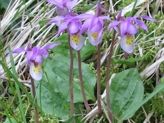
| Fairy Slippers or Calypso flowers on Pioneer Ridge Trail |
 |
| Smattering of snow on parks below Pioneer Ridge |
I've climbed Highwood Baldy as early as mid-April in a dry year and generally use June to tune up for my climbing by doing Baldy several times.
I think I'll be mighty lucky if I get one climb of Baldy this June because of the flooding.
On Tuesday we attempted to reach Baldy via the Geyser side and North Peak ridgeline.
Just beyond Geyser when we lost pavement we got blocked by a washed out culvert.
We decided to make the most of it and took backroads, Montana 551, a gravel road, to Geraldine and then got on pavement back to Fort Benton and home.
This scenic drive, that circumnavigates the Highwoods, offers tremendous views of Round and Square buttes and the east and north sides of the Highwoods.
This year the drive is particularly scenic because the countryside is almost shockingly green from all the moisture we've received.
Between Geraldine and Fort Benton there's a Scenic View pullout with interpretive signs explaining the unusual geology of this part of Montana, shaped by a volcano and an ice sheet that changed the course of the Missouri River.
When I got home I took a nap and decided to check out the road into the Highwoods via Thain Creek. I drove as far as the Belt Creek bridge and didn't see any signs warning me off, so I turned around, drove through Belt and went home planning for a return in the morning, perhaps to try Highwood Baldy or one of the ridgeline loops above Highwood Creek.
In the morning I drove to within a mile of the Thain Creek turnoff at the former Farmers Union summer camp (Now Arrowleaf) and a locked gate and closed road turned me around.
I was pretty determined to get in a hike, so I headed back to Belt and then turned toward the Little Belts with a goal of the Pioneer Ridge in mind.
The ridge, which leads directly to Big Baldy, is located across U.S. 89 from the Belt Creek Ranger Station. It is a nine mile trail, and 4,000 feet of elevation gain to the summit.
I decided I would walk as far as the snow would let me.
I reached snow in just under 2,000 feet at about 7,000 feet elevation and then continued on for another 600 feet or snow before having lunch and coming back.
The snow was quite deep and would have been good to ski or snowshoe.
The trail, No. 734, is quite steep right from the trailhead. I gained those 2,000 feet in about three miles.
Because it is steep it offers great vistas in most directions. To the south I could see Neihart Baldy and Long peaks and in the distance the Showdown ski hill on Porphyry Peak ---- which still has tremendous snow.
To the west was Belt Park and the country above Pilgrim Creek. To the north the Belt Creek Canyon and Sun Mountain. Once I crested the ridge I could look to the north and see the snow covered Big Baldy Mountain at over 9,000 feet. This will make a great hike in several weeks.
The wildflowers put on quite a show. There was a hillside covered in the Fairy Slipper orchid, the Glacier Lily announcing the departure of snow, shooting stars, larkspur, penstemon and much more.
This is a lovely, if steep hike.
No comments:
Post a Comment