 |
| Here I am at the Chinese Wall |
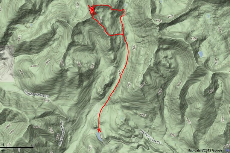
But not before ending the season with a four-day, 50-mile solo trip into the Bob Marshall Wilderness Area to walk along the Chinese Wall.
In weeks since my last post I've also climbed Arrasta Peak (elevation: 7,976 feet) in the Scapegoat Wilderness, and done an additional two trips in Glacier Park that included the 18-mile Dawson-Pitamakan loop in the Two Medicine area. There was also a nice climb to the base of Reynolds Peak in Glacier with my wife and a couple of other pleasant Glacier day trips.
The summer was marred by foul air coming from the Elbow Pass complex of fires in the Bob Marshall and Scapegoat areas and the many fire in Idaho. Many trails were also closed in those two areas and as of this writing the Benchmark area is still threatened.
Below, I'll review the hikes.
 |
| At a low pass between Burnt Creek and Moose Creek drainages below Cliff Mountain |
Chinese Wall in Bob Marshall Wilderness Area
I had been to the wall twice before, but the last time was 25 years ago and neither times did I walk the full Wall Trail. Both other times I approached the Wall from Rock Creek on its northern flank.This time I came up from Benchmark and the West Fork of the South Fork Sun River.
I think I like my latest trip better than the Rock Creek trip.
But cool weather blew in and the fires laid down and I had four pristine and even cool days for my hike.
I expected crowds of horsepackers and hikers, but saw very few other people.
 |
| Red Butte peaks near Indian Point on way to Wall |
It was interesting to note that the majority of hikers were Continental Divide Trail through-hikers on their way to nearby Waterton and completion of the trail walk.
When my brother, his wife and I did the North Wall last summer we also encountered CD trail hikers.
On Friday one of the parties was a search party for the Iraq War veteran who was lost on the Wall in 2010. When I came out on Saturday I was informed at the trailhead that he had been found and I saw the Army helicopter flying his remains out.
I put in 18 miles on the first day of the trip, arriving at Burnt Creek just below iconic Cliff Mountain, the beginning of the Wall you see on the trip.
 |
| The Wall sweeps unbroken for miles |
On my second day I walked that 7 miles back and forth, encountering no one until 4 p.m. The sky was clear and there wasn't a cloud . I felt as if I had one of the best Wall experiences anyone could have.
I didn't expect such lush, green grass along the Wall because the open hillsides below were all browned-out.
 |
| Breathtaking sunset above my final campsite |
What could I say about the Wall that hasn't been said? It is something I'd recommend every Montana kid do as they are growing up. The scenery is spell-binding and the Wall larger than anything you've ever imagined. It's like having a Glacier Park experience there --- with high, exposed hunks of rock for miles. There were lots of grizzly signs along the trail, but I saw none and did pick off some of the bears' huckleberries.
 |
| Indian Point guard station wrapped in foil |
There were plenty of nice camps at every open water site along the West Fork trail.
My final night was spent in the open West Fork country near the pack bridge. There was a heavy frost and I heard elk bugling. Winter is coming. I also smelled the fire just over the divide, an ominous sign of a fire season that hasn't yet ended.
Arrasta Mountain (elevation: 7,976 feet) in Scapegoat northwest of Lincoln
 |
| Approaching Arrasta Peak in the Scapegoat Wilderness |
Mark Hertenstein thought Arrasta Peak might be a good objective on Aug. 19 and we had a most satisfying loop hike there.
We chose a route that goes from the Meadow Creek Trailhead No. 482 into the Scapegoat, picked up off the Beaver Creek Road and parked near Reservoir Lake.
 |
| The red rocks of Arrasta peak in the Scapegoat. |
We hiked up the trail a couple of miles, found the summit ridgeline just south of the Porcupine Basin and walked a ridge line to the top. The adjacent peak across a short saddle is four feet higher. It looks as though it might have been an old Forest Service lookout site.
We walked down the ridge to a small lake and the trail and out.
Views from the peak were terrific ---- Meadow Creek, Red Mountain, deep into the Bob Marshall. There were several fires going on and we had a perch to view them.
Family visits to Glacier
 |
| Katie at pass below Reynolds Mountain off Logan Pass near Dragon's Tail. That's Hidden Lake below and Mount Cannon above. |
Summer is the time for family visits and we had two in one week; one from Katie's son Chip from Salt Lake City, and one from my daughter, Leila, who lives in Portland.
 |
| Chip Myers at Old Man Lake beneath Flinch Peak. |
 |
| My daughter, Lei, at Red Rock Falls near Many Glacier |
We found tons of great huckleberries and hordes of people during this peak season in the park.
I don't remember the park ever being more full of people. In Two Med the parking lot was full and the access point the camp store used as a parking area.
1 comment:
The place looks amazing! You are so lucky to have managed to get your way around such a beautiful place. I could just imagine the awe that you have found feeling while you are at that place. Don’t stop climbing mountains while you still can. It is a blessing on its own.
Post a Comment