Thursday, October 26, 2017

Snow capped peaks, blue skies, larch in color.  How could it be better?

Larch in color everywhere

Hiking through the Rice Ridge Burn

Braver than me, Wayne, 76, crosses the deep, cold, swift North Fork on narrow logs

Suzy Taleff goes across the North Fork 
We set out to see the larch in their fullest color Wednesday, and see them we did.
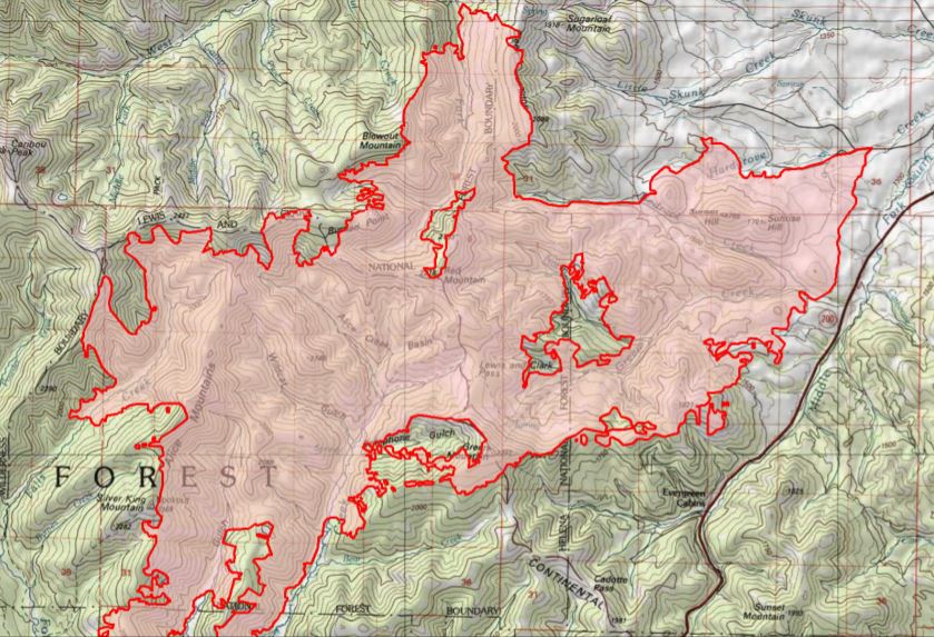
But our trip into the North Fork of the Blackfoot River area on the edge of the Scapegoat and Bob Marshall Wilderness turned into a look at the massive Rice Ridge Fire that burned most of the summer and resulted in evacuations at Seeley Lake.
We were surprised that the 160,000 acres blaze reached this far east and with such force.
Our trip, designed by hike leader H. Wayne Phillips was a 7.2 miles loop that started at the Bear Creek Trailhead and ended at the North Fork Blackfoot Trailhead.  We gained more than 1,300 feet of elevation and most chillingly, some of us forded a (crotch) deep and icy Blackfoot fork at the end of the hike.  Wayne and Shelli Liknes had enough courage and balanced to cross on some logs hewn by firefighters.
This was a hike of contrasts, from the snow-covered peaks to the north and east, to the grassy bottoms strewn with deadfall.  There were the lush and colorful larch, but there were also burned moonscapes where the Rice Ridge fire declared out only as late as 10 days ago where it met the big Canyon Creek burn in 1988.  We were impressed by the the regrowth in the Canyon Creek Fire and surprised at the breadth of the Rice Ridge Burn this year.
Deadfall across the Bear Creek Trail
We parked cars at the North Fork Blackfoot and Bear Creek trail heads and hiked through bottoms with high, snow-covered peaks in the distance, yellow and orange larch spangled hillsides in every direction and the burn of summers present and past within view.
The Canyon Creek fire of 1988 took out 250,000 acres in 1988 and the Rice Ridge fire burned across the mountains from the Seeley Lake area this past summer, scorching 160,000 acres meeting in this area.
We hopped over and around innumerable deadfalls in the trail, making the going slow.
Toward the end of the hike in the fierce burn of last summer, the trail became difficult to follow.
This trail will need a tough crew to clear it for the average hiker.
Be prepared for the Blackfoot crossing at the end!
A half-mile descent above Prairie Lake (swamp) might have been the prettiest part of this off-the-charts beautiful hike.  It offered shaded views of the swamp, mountains to the east and unburned timber.

For map and more photos, CLICK HERE

Golden larch nestled in the Doug Fir

Hillsides of colored larch

The North Fork Blackfoot valley reminded me of the North Fork Flathead valley

The Rice Ridge fire perimeter in pink


Tuesday, October 24, 2017

Fall colors: the Swan, Middle Fork Flathead

The Swan Range above Holland Lake

Swan Lake reflections 
The larch light up the Swan Lake hillsides


At Essex, the train overpass and Snowslip Mountain in full color
The winds died down sufficiently for us to take our annual Fall color tour around the Bob Marshall Wilderness Complex on Monday:  along Montana 200 over Rogers Pass, through Lincoln, up the Swan via Seeley Lake and Swan Lake, on the southern edge of Glacier Park, over Marias Pass, through East Glacier Park and Browning and back to Great Falls via Valier cutoff.
On the Montana 200 portion the larch were plentiful from Ovando on, but somewhat muted.  We had arrived about a week late for the height of color.
Along the Swan, from Salmon Lake on to Glacier, the colors were spectacular and the larch everywhere up the slopes of the Missions and the Swans.
There were still some cottonwoods in color

Katie on the banks of Swan Lake

Friday, October 20, 2017

Assessing the Alice Creek Burn

Fire turned north flank of Green Mountain into a moonscape

A sampling of Alice Creek hillside

Wayne Phillips in the burn

The Continental Divide Trail on Green Mountain served as a fire break
Now that the fire season is over it's time to have a look at the new landscapes.
On our Wayne's Wednesday Walk this week we surveyed the Alice Creek fire that started with a lightning strike in early July, smoldered for a month and then blew up before being put down by snow in mid-September.
It burned some 27,000 acres in its path on the edge of the new Scapegoat Wilderness Addition.
This is Continental Divide Trail country that provides the best access to Lewis and Clark Pass.
It is some 85 miles from Great Falls, about 18 miles from Rogers Pass.
We were in high wind season and the area was under a Weather Service alert for the gusts that were predicted at 70-80 mph.
What we saw was a fire that took out the main Alice Creek drainage and spotted in many areas on and adjacent to the Continental Divide Trail.  The area directly north in the Falls Creek drainage had burned in the Canyon Creek Fire in 1988 and several other subsequent years.
We were surprised by how pleasant the hiking was, despite the fire.  There were some moonscapes on the flanks of Green Mountain and the timber had been scorched to the edge of Alice Creek Road, jumping it in spots.
But, this is open country with alternating timber and grass, and the fire effects were more interesting than repulsive.
Our goal was to climb Green Mountain (elevation: 7,453 feet), but the wind blew so hard we climbed the northern-most false summit some 200 feet shy of the mountain high point, or 7,200 feet.
I figured we covered more than 5 miles and 1,600 feet of elevation, a task made difficult by the wind gusts.
Wayne Phillips took some photos and made some observations, taking GPS coordinates for return trips to measure the fire's effects in future years.
The Alice Creek fire perimeter in red


Thursday, October 12, 2017

Fall colors on Mount Kennon climb in Highwoods

Approaching Mount Kennon

We gained elevation quickly 
Gordon Whirry doing what he does so well


One of the many laccoliths on this climb

We bumped into some snow along the way

The Shonkin Ranger Station

The colors along Shonkin Creek were superb
This is a Fall-colors off-trail ridge walk that included a climb of Mount Kennon (elevation: 5,616 feet) from the Shonkin Ranger Station on the north side of the Highwood Mountains.The most difficult part of this hike is finding the trailhead on the gravel roads outside Highwood toward the ghost town of Shonkin.  Take a good highway map and be prepared for rough road for the last several miles.  I would suggest parking before crossing the creek.  We drove up the rough road to the Shonkin Station. The topography is the low-slung and grassy cattle country with great, open views to the north of the Bearspaw Mountains, to the east, Square and Round buttes, and to the west the high peaks of the Highwoods --- Baldy, Arrow, North, East peaks.  Last year we hiked from this same ranger station up Prospect Peak.  The area is covered with laccolith outcroppings that in spots form walls of volcanic debris.  The cottonwood and aspen bottoms were in full color.  We gained over 2,200 feet over more than 7 miles, returning from the ridgeline down the Shonkin trail.

For a map and other photos, CLICK HERE