 |
| Fire turned north flank of Green Mountain into a moonscape |
 |
| A sampling of Alice Creek hillside |
 |
| Wayne Phillips in the burn |
 |
| The Continental Divide Trail on Green Mountain served as a fire break |
On our Wayne's Wednesday Walk this week we surveyed the Alice Creek fire that started with a lightning strike in early July, smoldered for a month and then blew up before being put down by snow in mid-September.
It burned some 27,000 acres in its path on the edge of the new Scapegoat Wilderness Addition.
This is Continental Divide Trail country that provides the best access to Lewis and Clark Pass.
It is some 85 miles from Great Falls, about 18 miles from Rogers Pass.
We were in high wind season and the area was under a Weather Service alert for the gusts that were predicted at 70-80 mph.
What we saw was a fire that took out the main Alice Creek drainage and spotted in many areas on and adjacent to the Continental Divide Trail. The area directly north in the Falls Creek drainage had burned in the Canyon Creek Fire in 1988 and several other subsequent years.
We were surprised by how pleasant the hiking was, despite the fire. There were some moonscapes on the flanks of Green Mountain and the timber had been scorched to the edge of Alice Creek Road, jumping it in spots.
But, this is open country with alternating timber and grass, and the fire effects were more interesting than repulsive.
Our goal was to climb Green Mountain (elevation: 7,453 feet), but the wind blew so hard we climbed the northern-most false summit some 200 feet shy of the mountain high point, or 7,200 feet.
I figured we covered more than 5 miles and 1,600 feet of elevation, a task made difficult by the wind gusts.
Wayne Phillips took some photos and made some observations, taking GPS coordinates for return trips to measure the fire's effects in future years.
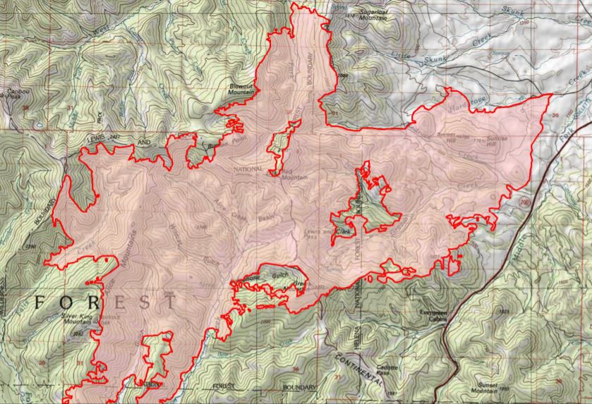 |
| The Alice Creek fire perimeter in red |
No comments:
Post a Comment