Saturday, May 28, 2022

Week's worth: Rogers Pass, Gold Butte, Two Medicine Ridge

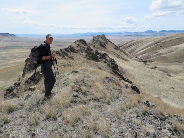
Lunch break on top of Gold Butte in the Sweetgrass Hills looking out toward West Butte

Descending to the dry plains from Gold Butte

Gold Butte in the Sweetgrass Hills

Katie and Laurie Lintner on Two Medicine Ridge lookout site

Wilbur Falls at Many Glacier

Pink Douglasia alpine flowers at Rogers Pass

Blue and yellow alpine flowers mimic the Ukrainian flag

 The alpine flowers have sprung into full flower, and despite the ultra-dry weather, the prairie is in bloom as well.

I always look forward to the time of year that the Forget-Me-Nots bloom, and now for the next couple of weeks you'll find these fragrant, colorful blue dots on alpine ridgelines.

This past week the trees in town finally started to leaf-out so we headed out to the Belt Creek valley and found a sea of greenery.  

It was such a treat and relief from a long winter and a cold, dreary spring.

On Monday I headed up to Rogers Pass on the Continental Divide and walked up Rodgers Peak on the east side of the pass and to the ridgeline on the west side, covering about 2,200 feet of elevation gain and loss on the Continental Divide Trail.

On the Rodgers Peak side there were about three inches of soft snow for the final 500 feet to the top.  On the west side, it was clear.  The pink Douglasia was blooming in profusion with the Forget-Me-Nots just starting.  I would think the next 10 days would be the time to see these blue beauties.  The cool spring is holding the snow in the high country here on east and north facing slopes.

The prairie is another matter.

It is bone dry, and that spells real trouble in our area that is in extreme drought anyway.

We found the prairie heading to Gold Butte in the Sweetgrass Hills on the Canadian border, a gray-brown mass of dry.  There were some flowers, but this country should be green by now.  About the only green we saw were fields where the winter wheat is going.

We had hoped to climb the butte --- really a steep mountain of igneous talus ---- from Cameron Lake on its west side, along the route we had done 17 years ago.

The problem was that the road was so rutted that the car's bottom scraped and we had to park nearly a mile from our planned departure spot.   We figured it added about 2 miles to our trip across long, brown fields and required us to crawl under four fences and go through a gate.

Our normal route up this mountain is from the town of Gold Butte, and we had along with us Gordon Whirry, whose great grand parents homesteaded the area.  He knows the ranch families in the area and history of this country.

I was pretty slow going up and coming down the extensive, large talus on the final 600 feet up to the top of the peak, and my thighs were really sore the next day.

Despite that soreness, we went to Glacier on Thursday and visited Two Medicine and Many Glacier .

Friend Laurie Lintner, who grew up in East Glacier Park, accompanied us and treated us to a hike to the site of the former fire lookout on top Two Medicine Ridge just above the pass at Looking Glass Highway.

We were treated to phenomenal views into Glacier and then a walk across the ridge.

I came away with ideas for cross country skiing here, and then saw a nice alpine lake at the base of Spot Mountain to the northwest.  Laurie pointed out that above the lake is the Boundary Trail that goes across that base and into the Cut Bank Creek area.  I need to go.

There were other hikes during this period including River's Edge Trail from Giant Springs to Crooked Falls Overlook, where we found many prairie flowers including golden pea and penstamin.  Wa also went the Belt Creek Ranger Station in the Little Belts to look for the Fairy Slipper wildflower and found several on Crawford Creek and Pioneer Ridge trails nearby.  However, we're early for those.

And, then one more trip to Rogers Pass to check the progress of the wildflowers and found that the Forget-Me-Nots were now in full bloom.


Thursday, May 19, 2022

A full week of hikes: Lionhead (again), Limekiln in Judiths, Windy Highwood, Falls Creek

Our Wayne's Wednesday Walks group gingerly descends Lionhead Butte north slope

Falls Creek is a truly wilderness water

Our Falls Creek lunch break

The main Falls Creek falls

 Hiking season appears to be in full swing.

In the past seven days we climbed Lionhead again, did the Limekiln loop in the Judith Mountains, went to the base of Windy Peak in the Highwoods, and hiked Falls Creek in the Rocky Mountain Front to the West Fork.

Things are greening up and emergent wildflowers are everywhere. And, the ticks are out on the Rocky Mountain Front.

Gosh, we live in a great place with amazing things to do in every direction.

These are all hikes I've done before, but I have to admit that I enjoyed the Falls Creek hike the best.  Maybe because I love the Front the best.

Grizzlies are obviously out.  We found a large, fresh scat pile on our Falls Creek hike.

It's dry everywhere.  We found clear, low streams, and in some places no water.  The Judith Mountains were particularly dry.

We stayed at the Pheasant Tales Bed and Bistro south of Lewistown off Spring Creek, our first bed and breakfast experience since Covid.  The rolling, green hills were a refreshing break from Great Falls and we were thoroughly entertained by Dr. Taylor and his wife who run the place in their retirement.

In addition to our Limekiln hike, we stopped at the new American Prairie headquarters in downtown Lewistown and were impressed with the displays at the museum.  They drove home the importance of the prairie ecosystem that revolves around the bison.  We could have spent the afternoon there.

On the way home, we took a circuitous route along the base of the Moccasin Mountains along U.S. 81.  We wanted to see the aftermath of fires that had swept through the Moccasins and destroyed a portion of the little town of Denton.

We were surprised to find a developed Warm Springs at the base of the Moccasins that we didn't know existed.  I'm not sure it is open right now.  It had suspended visitation during Covid.

Denton didn't look as bad as I expected.  The cleanup has been extensive.

On Lionhead we traversed the high point and our Wayne's Wednesday Walks group got a thrill negotiating a steep north face.  From the top we saw two elk.

The Highwoods are waking up, starting to show green, grassy slopes.  We saw our first arrowleaf balsamroot flowers of the year there.  We were surprised to find that metal bridges had been placed across the nine crossings of Thain Creek on the trail to Windy Peak. It made those crossings much more pleasant, although the creek was as low as I have ever seen it in the Spring.

Going out, we took the high, unofficial horse trail on Falls Creek that allowed us to bypass crossing the creek on the regular trail.  We stopped at the big falls coming and going, dropping down to the creek at Twin Buttes Creek where we stopped at a rocky glen for a break near rushing creek.  Going back we dropped to the creek not far from the other major waterfall, where we stopped for a look.  We saw our first glacier lilies of the year on this hike, as well as sugar bowls and clematis.  Lilac colored phlox lined the trail in many spots and there were Pasque flowers in profusion.  The whole area felt very wild.


Friday, May 06, 2022

Great Falls area buttes are a treasure

On the way up Shaw Butte

Walking the Shaw Butte ridgeline

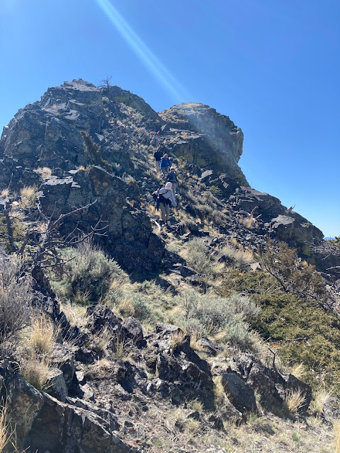
The spike at the end of the Shaw Butte ridgeline we climbed

Gordon Whirry reaches the top of Lionhead Butte

Our lunch spot on the Lionhead "ramp" to the top

Great views of Birdtail Butte as we came off Lionhead

I think those of us in Great Falls take our magnificent scenery for granted, or downplay it when comparing it to the scenery in the Flathead or Gallatin.

That's too bad.

In this in-between season, the so-called "shoulder" between winter and summer, skiing and hiking, I've found right at my doorstep what could be considered national scenic treasures, our local buttes that dominate the landscape mostly west of Great Falls.

The most prominent is probably Square Butte (popularized by cowboy artist Charlie Russell).  The most hiked is probably Crown Butte (because of the access granted by the Nature Conservancy). Between these two is long and low-strung Shaw Butte.  East of Fort Shaw, Birdtail Butte and Lionhead Butte are hard to miss on the skyline.  There are numerous other buttes in the Birdtail-St. Peter's Mission areas, most on private land.

These buttes are volcanic remnants formed by tubes of lava flowing from an old volcano in the Adel portion of the Big Belt Mountains up through cracks in the earth.  These "dikes" have created long, craggy ridge lines.

This past week I climbed to the top of two of these buttes for the first time --- Lionhead (elevation: 5,051 feet) and Shaw (elevation: 4.541 feet) --- and been treated to thrilling views of the surrounding buttes, the Rocky Mountain Front and several "island" mountain ranges.  Both are reachable via the Birdtail Road just east of Fort Shaw.

Shaw Butte is normally open (with permission) from the adjacent Cascade Hutterite Colony.  There's block management hunting during the fall.

We went directly up from the Colony through some cliffs an then grass to the flat top, meeting a band of domestic sheep along the way.  To the north we could look down into a deep ravine and the ridge line above that climaxes in a pointed spire above a large gravel pit below.  

After enjoying the views from the top, we crossed over to that adjacent, serrated ridge and climbed the spire, before dropping back down to the gravel pit and over to the Colony.  Our hike was only 4.3 miles with an elevation gain and loss of 1,250 feet.

Shaw and Lionhead were dotted with emerging wildflowers, dominated by kitten tails, yellow bells, shooting stars and Pasque flowers.

We liked our Shaw Butte experience so well that two days later we headed to Lionhead, which sits directly across a draw from the more dramatic and unclimable Birdtail Butte that dominates the area.

Both Birdtail and Lionhead are open to hikers through a 4,000 acres conservation easement.  You can drive in through a wire-gate.

Lionhead has an impressive cliff band that must be breached and there are several ways to do it, with the most easy being looking to the east where there is a break in the cliffs and noticing a grassy "ramp".  Use this ramp to get to the top and then follow it as it bends back toward a prominent peak of about 100 feet that is easy to scramble.

We descended the east along the ridgeline and my partners scrambled the length of the ridgeline.

With my balance and leg issues I descended about 50 feet from the top onto a grassy shelf and paralleled below my buddies about 50-100 below them.  It was an easy descent.

Once on the valley floor it is easy to go through a short canyon and come around the adjacent ridgeline and hike below the cliffs and out.  Instead, we reclimbed that adjacent ridge and descended that grassy ridge to complete this short trip. We had hiked only 2.8 miles, gaining over 1,600 feet.

Birdtail across the valley was a most impressive sight.

I'm somewhat surprised that these and the adjacent buttes haven't come under some kind organization to promote their recreational values.  Agriculture has won out here.