 |
| Rocky Mountain peak is in the Our Lake Addition to the Bob Marshall Wilderness Area under Heritage Act |
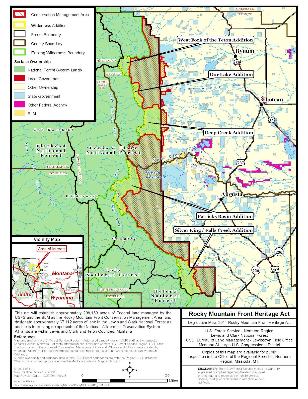
UPDATE: This post has been updated. An earlier version had incorrectly indicated that The Deep Creek Addition also includes the South Fork Teton River Trail No.168, along Rocky Mountain Peak’s east flank. Also, I had incorrectly indicated that it has yet to be determined if the lower reaches of Falls Creek were included. They will not be as per the agreement of all parties and the lines drawn on the Heritage Act map.
Access to the Bob Marshall and Scapegoat wilderness areas has gotten a whole lot easier with passage of the Rocky Mountain Front Heritage Act.
The act added five roadless areas totaling 67,112 acres in the Front to the Bob Marshall and Scapegoat, moving the boundaries of the wilderness closer to hikers, backpackers, snowshoers and backcountry skiers.
Dave Cunningham, information officer for the Lewis and Clark National Forest, pointed out that people have had easy access to these areas all along, but that they just weren’t called, “wilderness.”
It may be some time before the U.S. Forest Service finishes its review of boundaries and puts out a detailed map.
Rocky Mountain District Ranger Mike Munoz said that acreages in each of the areas, and which wilderness area, (the Bob or the Scapegoat) will have to be sorted out and approved by U.S. Secretary of Agriculture. With what I can gather from looking at current maps and comparing them to the proposed boundaries in maps published by the Save the Front organization, here are descriptions of the five areas with some ideas on how to reach them. These approaches will be covered in the new edition to my book that should be out before the hiking season.
 |
| Devil's Glen is now in the Scapegoat Wilderness Area |
- Silver King/Falls Creek. Think Dearborn River and the 6-mile round trip Devil’s Glen hike (Trail No. 206 ) and you’ve reached the wilderness boundary, in this case the Scapegoat Wilderness, part of the Bob Marshall Complex. Walk the Continental Divide Trail between the Alice Creek headwaters and Caribou Peak and you will also be in the Scapegoat.
 |
| Cross the South Fork Sun packbridge and you'll be in Patrick's Basin Addition to wilderness |
- Patrick’s Basin If you’ve ever climbed Patrol Mountain, the area immediately north and east nearly to the Benchmark Road, is now in the wilderness. You can now reach the wilderness boundary from the Benchmark Campground almost immediately when hiking the Straight Creek/Patrol Mountain Trail Nos.212/213. Patrick Basin also contains other large mountains like Allen and Sheep Shed that would be part of the Bob Marshall. A major access is Lange Creek Trail No. 243. (reached via Trails 202,242 or from Gibson Reservoir). Under the bill, you’ll be in the Bob and the Patrick Basin Addition nearly as soon as you cross the South Fork Sun Pack Bridge at Benchmark, Trail No. 202.
 |
| Deep Creek Divide from the Deep Creek Addition will now be part of the Bob |
- Deep Creek. This addition is a land of great gulches and high peaks. The rule of thumb here is that if the creeks flow toward Deep Creek, it’s in the Bob Marshall Wilderness. That would mean that hiking the Green Gulch/Reardon Gulch 19-mile loop (Trails No. 126,127,135) you’d be in the Bob along Slim and Sheep gulches, but not Green and Readon gulches. Another way to reach this would be via Blacktail/Mortimer gulches from the Sun River Canyon area (Trails No. 223).
 |
| The Our Lake Addition is now part of the Bob Marshall |
- Our Lake This is probably the Front’s most popular hike (Trail No. 184), but the wilderness boundary is moved closer to the parking area near the South Fork Teton, and includes the east side of Rocky Mountain peak, the highest mountain in the Bob. This addition also pushes the boundary closer to the trailheads of Headquarters Pass (Trail No. 165), and Route Creek Pass (Trail No. 108).
 |
| The ridge between Teton Pass and Washboard Reef is now part of the West Fork Addition to the Bob |
- West Fork Teton Just behind Mount Wright along Trail No. 114 to include the forks of the West Fork, like Wright and Olney creeks. The Wright Creek drainage, without a formal trail is particularly scenic with towering Mount Wright on the east and an extension of the limestone Corrugate Ridge to the west. Previously, the wilderness boundary had been at Teton Pass, a hike of 5.5-miles one way. That is a hike I’d highly recommend.
The Heritage Act also designates 208,160 acres of the Front as “Conservation Management Areas,” where the restrictive Forest Service Travel plans are now set into law. That means that much of the Front remains “de facto” wilderness without the title.
However, it would limit road-building while it protects current motorized recreation and public access for hunting, biking, timber-thinning and grazing.
And, importantly, the act prioritizes eradication and prevention of noxious weeds on the designated public lands. This, in turn, helps protect adjacent private lands.
Earlier, through the efforts of former U.S. Sens. Max Baucus and Conrad Burns and former Lewis and Clark National Forest supervisor Gloria Flora, the Front was withdrawn from oil and gas development.
The Heritage Act was passed through an amendment attached to the 2014 Defense Bill and represents a compromise supported by then U.S. Rep. Steve Daines, a Republican, and U.S. Sens. Jon Tester and John Walsh, both Democrats. It was signed into law by President Barak Obama.
Here's the Save the Front coalition's proposed Heritage Act map:
No comments:
Post a Comment