Wednesday, June 27, 2018

Route Creek Pass: expect more traffic this year

7-Lazy-P wranger leads his pack string through the pass


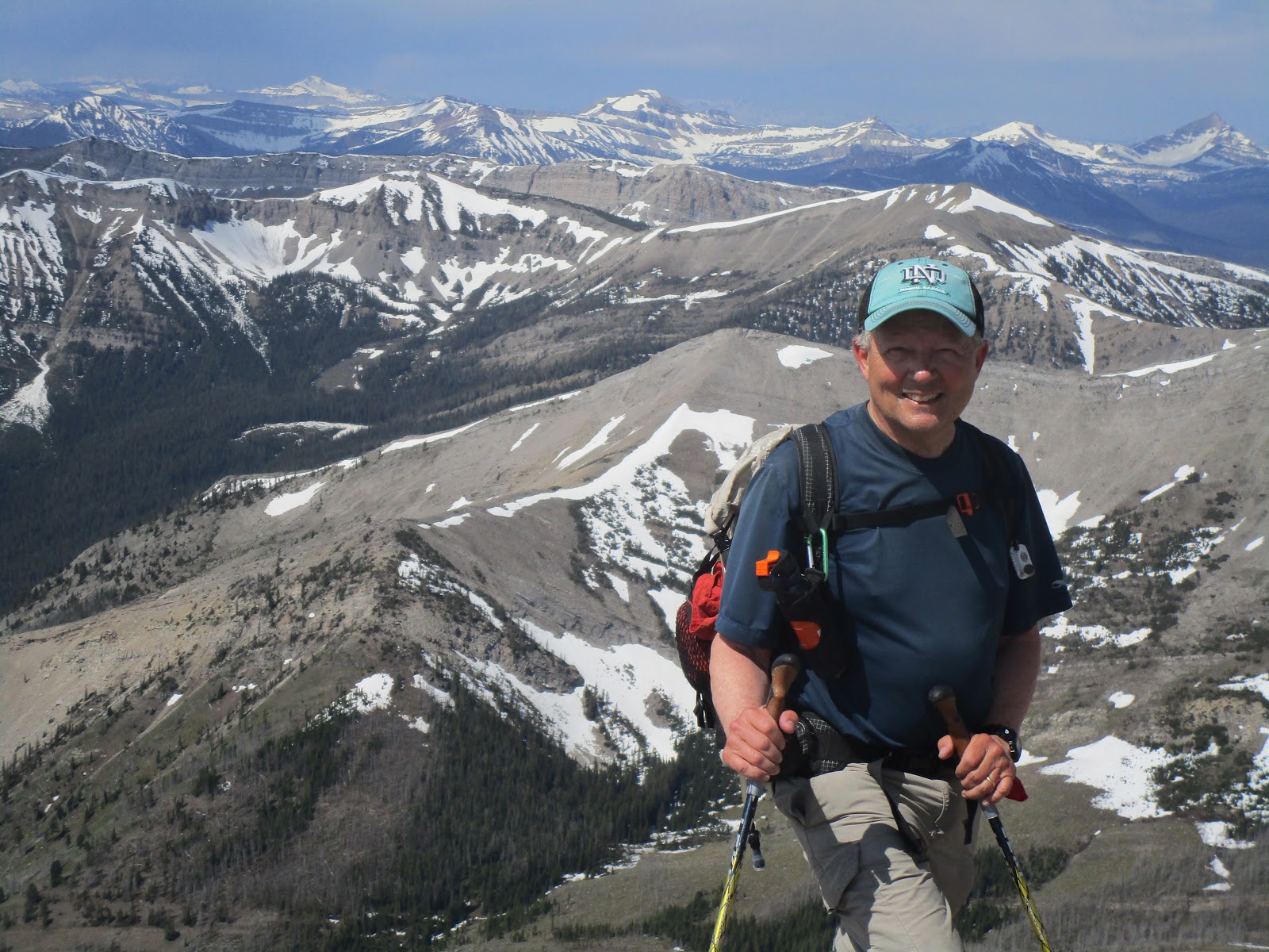
Old Baldy, a beautiful peak on a beautiful day

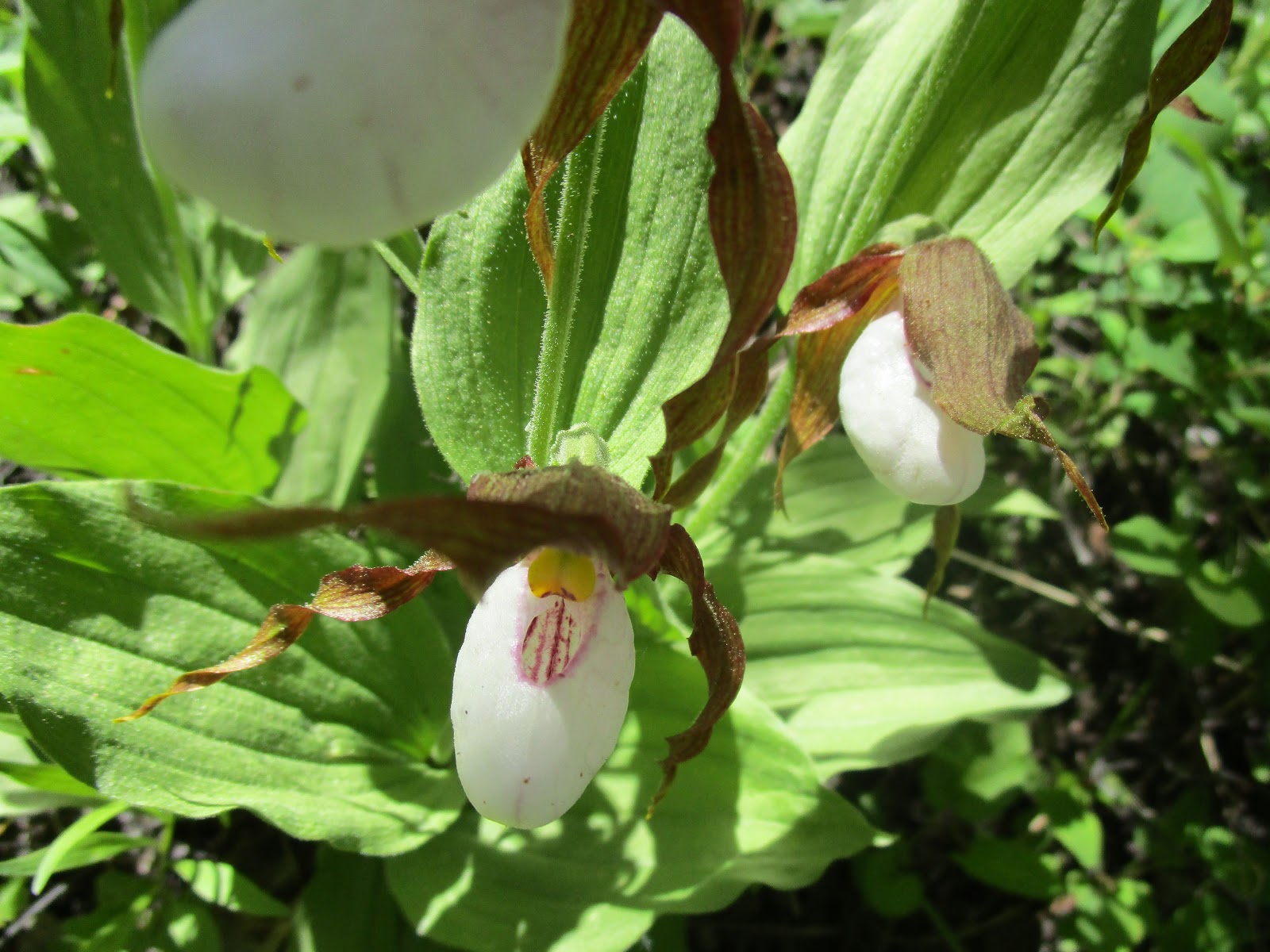
Lady Slipper orchid along the way

Just a sampling of the numbers of orchids
Last year we stopped just yards short of climbing to Route Creek Pass in the Bob Marshall Wilderness at the head of the Middle Fork of the Teton.  We could have made it, but the winds were so fierce they knocked us down with each step.
On Tuesday, a spectacularly beautiful and clear day, I went to the pass in windy conditons, which I didn't let stop me.
This is a 13.6 miles round trip hike with about 2,300 feet elevation gain and loss.
As I had done on Sunday I was checking out the access roads to the Front and found the main road up the Teton River, through the canyon, is just fine but the South Fork Road to about Mill Falls is closed, effectively cutting off access to hikers' favorites Headquarters Pass and Our Lake.
It also cuts off a main access point into the North Fork Sun River country through Headquarters.
I figure those spots remain open, like the Middle Fork Teton and Route Creek, will be humming with traffic that normally would have gone through Headquarters.
I got up there before the horses on Tuesday and had a wonderful hike, marveling at the snow fields on the flanks of Old Baldy and impressed with the high water volume in this little stream and its waterfalls.
Along the way closer to the pass itself I saw evidence of some winter avalanches that shredded trees that now lay in the bottoms.
The area is SOOOO green and the flowers plentiful.  I was surprised by a significant stretch of trail that had the Lady Slipper orchids.  This is obviously not a beargrass year.  Only one stubby beargrass on the trail.
Since I was hiking alone I started to notice things that hadn't occured to me on previous hikes in the Middle Fork.  The most significant is that this is a large drainage essentially untouched by fire or pine beetle kill.  If you want to see how the Bob Marshall looked before fires started raking the area and the Front in the early 80s, this is the place to go.  It is refreshing.
I was a little intimidated looking at Baldy, thinking how difficult it would be to climb now that I'm in my 70s.  It used to be a hop-skip-and a jump to the top.  Once I even climbed it in transit to the North Fork and Wrong Creek country....something to do along the way.  I'm losing strength on a massive scale.
Once I reached the top the traffic behind came by:  a 7-Lazy-P Guest Ranch bunch of about 8 dudes, two wranglers and a pack string going to Gates Park, followed by three Forest Service summer workers headed to Wrong Creek for maintenance work.  It was fun visiting with them. The pack strings were especially scenic.  On the way down, a couple of miles from the pass, I encountered 11 boys and their leaders with pack rafts in their impossibly large and heavy packs, headed for a float down the North Fork of the Sun. 
This is more traffic than I like in a day.
Finally, I don't understand why a trail had to be built from the new parking area at the trailhead rather than relying on the old one, which is just fine.

Monday, June 25, 2018

Checking flood damage and climbing Fairview Peak

One of the many impressive views from the top of Fairview Mountain

This is where I crossed Willow Creek

Relics of an old fire below the peak

I"m always impressed by this spring that empties from the limestone walls into Willow Creek

Willow Creek out of its banks swamping an old cabin

Sandhill cranes I encountered

Fairview Peak

Flood damage on Benchmark Road
A large snowfield beneath Fairview peak
I had no intention of climbing Sunday.
I had even walked in my neighborhood waiting for the rain to stop.
When it did about 10 a.m., I decided to drive to Augusta to check out the flood damage.
We had cancelled our scheduled Montana Wilderness Association climb of Fairview Peak in the Front based on Forest Service reports that the road into Willow Creek was flood-damaged and impassible.
Quickly I learned that the road between Simms and Augusta was closed and if I wanted to reach Augusta I would have to go by way of US 287 at Bowman Corner.  I passed by the town of Sun River and things looked pretty dry if disheveled from the water that had poured through that small village.  The worst of the flooding was obviously over there.
Going via Bowman Corner route added at least 20 miles to my drive to Augusta, but they were quite scenic and pleasant with flowers, particularly lupine, in spectacular bloom in the fields.  The grass seemed as green as Ireland to me.
Augusta was also dry, but one could see the gravel left by the raging Elk Creek.  Signs blocked the road to the Dearborn, Elk and Smith Creek trailheads.
I knew that the Sun Canyon Road was open, but had heard that Benchmark was closed, although I didn't know where, although I suspected just east of Wood Lake where there is always water damage in the Spring.
I had hoped that the Benchmark Road would be open at least to the Beaver-Willow Road junction and I could examine access to Willow Creek and the Fairview trailhead.
Along the way I passed really full reservoirs and lakes and noted fishermen at Nilan Reservoir.
There was only one major road damage spot, just beyond the lakes before the Cobb Ranch.  It was narrowed to one lane with orange pylons, and a deep gash, about 30 feet long indicated major water damage.
At the Beaver-Willow junction there were some ruts in the softened road, but nothing my car couldn't get around.
To my great surprise the Willow Creek road was in about the same shape it is always in ---- not great, but driveable.  I was able to get to the trailhead.
The only problems were that I would have to cross an out-of-its-banks Willow Creek at the beginning of the hike and it was well past noon and Fairview Mountain meant a 3,000 feet climb.
I donned my sandals and waded the ice-cold creek and noticed that an outbuilding on the adjacent farm in the middle of the creek's path.
Otherwise, the climb was pretty much as usual and I had great views at the top.
I was pretty proud that I reached the summit in 2 hours and 10 minutes and patted myself on my 70- year-old back in doing so.
This is an easy climb that delivers outstanding views into the Scapegoat and Bob Marshall wilderness areas.  It was surprising to see how much snow there is on the Scapegoat plateau in the Flint, Observation and Triple Divide peaks areas.
There were also large snow fields on Fairview's northeast peak.
Leaving the area I happened upon a couple of Sand Hill Cranes that clucked and gobbled in protest of my presence.
I'm concerned about the accessibility problems along the Front this hiking season because of all the bridges out and road damage.
I discovered a much quicker way home than Bowman Corner route, heading out of Augusta north on US 287 to the Fairfield cut across road, which is only six more miles further than the 52 Simms-Augusta road.


Saturday, June 23, 2018

Summer begins as downpour ends: Windy Peak-Briggs Creek loop in Highwoods

Lady Slipper orchids

Gordon Whirry coming off Windy Peak

Sulphur flowers in abundance

One of my favorite summer treats:  billowing white clouds on a clear day

Briggs Creek was clearer than usual

Butterflies added to our enjoyment

We complete the day with dry feet!
After the wonderful Mortimer peak climb on Saturday I was pinned down for another five days as the skies opened and 8 inches of rain fell, flooding and isolating Augusta and Sun River and taking out culverts, roads and bridges throughout the Front.
It's hard knowing if and when we'll be able to use the Benchmark, Elk Creek, Willow, Dearborn, South Fork Teton, and Smith Creek roads.  This could be a grim summer for recreation.
So, when the rain stopped I shifted my focus to the Island Ranges and took a short-tenative hike in the Little Belts on Pioneer Ridge on the final day of Spring (June 20), found it passable and planned a Highwoods hike.
We did the 7.5 miles Windy Peak-Briggs Creek loop on the first day of Summer (June 21), gaining and losing 1,700 feet along the way.  The weather was ideal with poofy white clouds against a backdrop of clear, blue skies.  The grass was greener than green and the wildflowers still pretty good.  We were even treated to Lady Slippers, but the blue lupine stole the show for numbers and colors.
There are nine Thain Creek crossings along the way to Windy Peak, but there were logs and rocks down most of the way that made the higher than usual tiny creek more easy to cross.
Briggs Creek, usually smaller than Thain Creek, was about twice Thain Creek size.  Thank goodness for the large Doug Fir across the creek at the end.  We wound up with dry boots!
The Briggs Creek beaver ponds continue to grow and a fly fisherwoman at the end was testament to its fishing.  Moose droppings everywhere there tells me there's a big-antlered resident there competing with the beavers.
The roads are in great shape, but I'd be careful about trying to take your car across Highwood Creek.

Saturday, June 16, 2018

Backcountry season is upon us: Highwood Baldy, Ford Creek Basin, Mortimer Peak

The large peak in the background is Mortimer, which we climbed


Walking down the ridge line

The weather, if windy, has been magnificent and perfect for hiking and backcountry scrambling.
This past week I climbed Highwood Baldy (elevation: 7,670 feet) , hiked Ford Creek Basin (Trail 258 off Benchmark/Willow Creek roads) in the the Front, and climbed an unnamed peak (elevation: 8,275 feet) at the head of Mortimer Gulch near Gibson Reservoir.
Although all were great trips, the climb up "Mortimer" was the highlight and something I've been wanting to do for years.
Last year we took a bad route and got cliffed out.
This year our route, though less direct, was spot on and we enjoyed some of the best 360 views from the top that I've enjoyed in the Bob Marshall country.
Arsenic peak to our west

We climbed up the right side and traversed the top and ridge to the peak

Castle Reef mountain across the valley

"Mortimer" Mountain

As we came down in defeat last year I studied the ridge line to the east and saw a clear route to the top.
This year we followed that and the trip was a success with 3,800 feet gained and lost and 12.2 miles covered.
We followed the Mortimer Gulch Trail No. 252 for about 4 miles where the (unsigned) Mortimer Pass comes in from the northwest.  We hiked another half mile or so to a creek crossing and bushwhacked up to a ridge line that was continuous to the top, climbing five or so "bumps" along the way.
On the way up we got off the trail too early and got tangled in deadfall, but on the way down we could see a clear climber's trail that ended at the creek and a hunter's camp.  I figure that the Triple J guest ranch at the bottom of the gulch would take dudes to the camp, do an overnight and then walk the ridge line to the top, giving them the thrill of their lives.  My climbing partner Mark Hertenstein figured it was simply a game trail.
The Mortimer Gulch trail is a National Scenic Trail. 
The handsome, unnamed mountain at its head can be traversed on a system of trails that include Blacktail Gulch Trail No. 220, Big George Gulch Trail No. 251 and the Mortimer Pass Trail No. 259.
The ridge line narrows down to a knife for the last 200 feet of elevation gain or so over about a third of a mile to the top, but nothing scary.  It reminded me of the Washboard Reef off-trail traverse or Mount Lockhart.
On top we saw three climbers' cairns and some of the most incredible views of the Bob country in all directions.  There's still plenty of snow in that country and we found pretty good drifts on this peak.
We noted that last year's route was more of a straight shot, but would have required ropes to get through the cliffs in at least one pitch.
I was unsure whether I was up to this climb so early in the season and had been working up to it, but found I was plenty fit and up to the climb.
Our route

Ford Creek Basin Trail


Views from one of the Ford Creek Basin meadows
This was also a week of bungling hikes.
Hard as it is to believe, we screwed up the Ford Creek Basin 5 mile hike, which I would consider near beginner, and wandered around looking for trail.  This was an out and back hike that gained 1,300 feet.  We began at the trailhead on Willow Creek Road behind Scoutana camp and ended at Ford Creek Ranch on the Benchmark Road where we had another car parked.  The wildflowers were stunning as were the views of the Crown Mountain, Steamboat and Haystack complexes.  There were numerous fresh grizzly, moose and elk signs.
Somehow we managed to start the hike off trail and ended up having to correct, a correction that took us through a field resplendant with the season's last Balsamroot Arrowleafs and many Larkspur wildflowers.

Highwood Baldy

Greener than green and full of flowers Highwood Baldy
I normally do Highwood Baldy at the beginning and the ends of each season.
The snow was off the top of this peak early this year.
There are several routes to the top.
The Deer Creek route up the bottom is the most frequently used one.
In the spring I like to go to the ridgetop for flowers and choose a route that starts at the Stephenson Ranch fenceline just before the second crossing of Highwood Creek on the road just beyond the Thain Creek Campground turn off.
There's a bridge between the Stephenson ridge and the ridge above Deer Creek.  It's a little complicated and requires attention.
My problem was that when I got to the trailhead I discovered that I didn't have a map and that my GPS was out of battery;  I had to go blind.
Getting up the peak was no problem navigationally, but getting down I found myself dropping into McMurtry Creek rather than hitting the Stephenson ridge line.
The positive side of this was that I discovered beautiful open parks and very tall aspen trees on the Stephenson Ranch and still came out only about 100 yards from my car.
This island range high point is surprisingly difficult to climb, with more than 3,200 feet of elevation gain, and significant route finding on the summit cap through tons of talus.


Sunday, June 10, 2018

A rite of Spring: Mount Wright

The Jones Columbine were everywhere along the summit cap 

Mark Hertenstein beneath the peak

The Bob Marshall's Sun River country to my back

The snowfields on the east flank of Mount Wright
The weather was supposed to be stormy, but it held off long enough Saturday for us to climb Mount Wright (elevation: 8,795 feet) in the Rocky Mountain Front.
There's plenty of snow on the mountain's East flank that climber's face on the trail route.
We may have been a week to 10 days early for the best alpine floral show, but the Jones Columbine, Forget-Me-Nots, and Douglasia were out.  It might have been the best show of Jones Columbine I've ever seen.
A grizzly had been rototilling in this rock garden for biscuit root.
The snow in the Bob Marshall Wilderness in the Sun River drainage appears to have mostly melted, with patches and cornices near the top.
Further back in the Bob, Pentagon, Silvertip and Holland peaks look loaded on the West Side.

Friday, June 08, 2018

A month's worth of travel and hiking

Katie and me on our wedding anniversary hike in Glacier

Katie in Maritime Alps in Italy above the town of Roaschia

A storm moves in as Katie signs the register on West Butte in Sweetgrass Hills

Wayne Phillips passes through a floral garden of pink Douglasia and blue Forget Me Not alpine flowers on Rogers Peak
It has been more than a month since my last post, but that doesn't mean I haven't been active,
We spent 22 days in France and Italy (via YYC Calgary Airport) with hiking in the Maritime Alps between those two countries; an anniversary hike around Two Med Lake at Glacier National Park when we got back, our annual trip to the Rogers Pass section of the Continental Divide Trail to view the alpine flowers on Rodgers Peak, and a trip up West Butte in the Sweetgrass Hills with Katie's "Girls in Glacier," hiking group.

Maritime Alps

There are national parks in both France and Italy in the Maritime Alps, which are about 50 miles north and east of Nice, France.  They are directly south of massive Mount Blanc.
We stopped in Roaschia, Italy where Katie's paternal ancestors came from.  It is an area south of the better known town of Cuneo and not far from Turino.
We hiked to an area near a rifugio that reminded me of the Rocky Mountain Front with its high, limestone walls.  However, the lower elevations are filled with hardwood trees like Sycamores and Horse Chestnuts and maples, giving the mountains a different feel than Montana slopes.
Last year we spent three weeks in the Dolomites across Italy on its northeast side just below Austria.  That area is filled with high-end, glitzy shops and ski lifts up every drainage.  Money.
Where we went in the Maritimes was equally beautiful, except there are no ski lifts and we saw only two other people on the trail on a beautiful day of spring hiking.  The rivers and creeks were the color of the Flathead River, meaning they were coming off glaciers.
The Maritimes are dotted with small, isolated communities like Roaschia.  Little villas known as tetti are built in the heavy forest above them.  Most of these stone structures, built in the 17th and 18th centuries are now abandoned, virtual ghosttowns.  No wealth here.  These towns empty out in winter and few come back during the summer.  The locals are puzzled about how to regenerate populations and are proposing that the Maritime parks incorporate them within their boundaries.  Seems pretty bleak to me.
Roaschia has a summer population of about 100 and there is a restaurant and a hotel to service the population, which shops in Cuneo.
In France our hiking was limited to walking and seeing the sights and museums in such great cities as Paris, Lyons, Nice and Bordeaux.  We did get out to the Pyrennes where we had to opportunity to climb a small mountain and straddle the French-Spanish border with a foot in each country.
I loved the Pyrennes and would love to return to these mountains, which seem so less congested than the Alps.

Glacier is incomparable

We were treated to amazing weather in Montana when we got back and took full advantage.
Glacier in incomparable.  That park and our Rocky Mountain Front country visible on a drive there world class scenery-wise.
We have the added advantage of access to truly wild and sparsely visited landscapes.
I'll take our Montana scenery over anything I've seen in Europe.

Rodgers Peak alpine flowers

Our alpine wildflower tour of the Continental Divide Trail off Rogers Pass was amazing.
The blue, fragrant Forget-Me-Not flowers stole the show, spangled on the red arguilite stone amidst the yellow graba and the pink Douglasia.
In the distance the snow-capped Scapegoat Wilderness high-point, Red Mountain at 9,411 feet.
It doesn't get any better than this!

West Butte:  Sweetgrass Hills

On Thursday Katie asked me to lead her "Girls in Glacier" hiking group up West Butte in the Sweetgrass Hills.  The butte (really a mountain) at 6,983 feet, rises abruptly from a flat, agricultural plain.  Up against the Alberta border it is the highest of three such buttes north of Shelby/Chester.
I lead 15 women from our parking spot.  Fourteen reached the top as the Great Plains sky put on a tempestuous performance.  We could see storms moving in as we neared the top, causing us to take cover in a wooded area as rain and hail pelted us.
I thoroughly enjoyed the drama of the malevolent sky bringing moisture.
From the top we could see the other buttes floating on the prairie as dark clouds descended on them.
This is a sacred spot for the Blackfeet Indians and we saw prayer flags in the threes on top where they do vision quests.